
3 cities | 2 service types

Drone Survey Services and Aerial Mapping Across Odisha

All Services
SurveillanceLiDAR
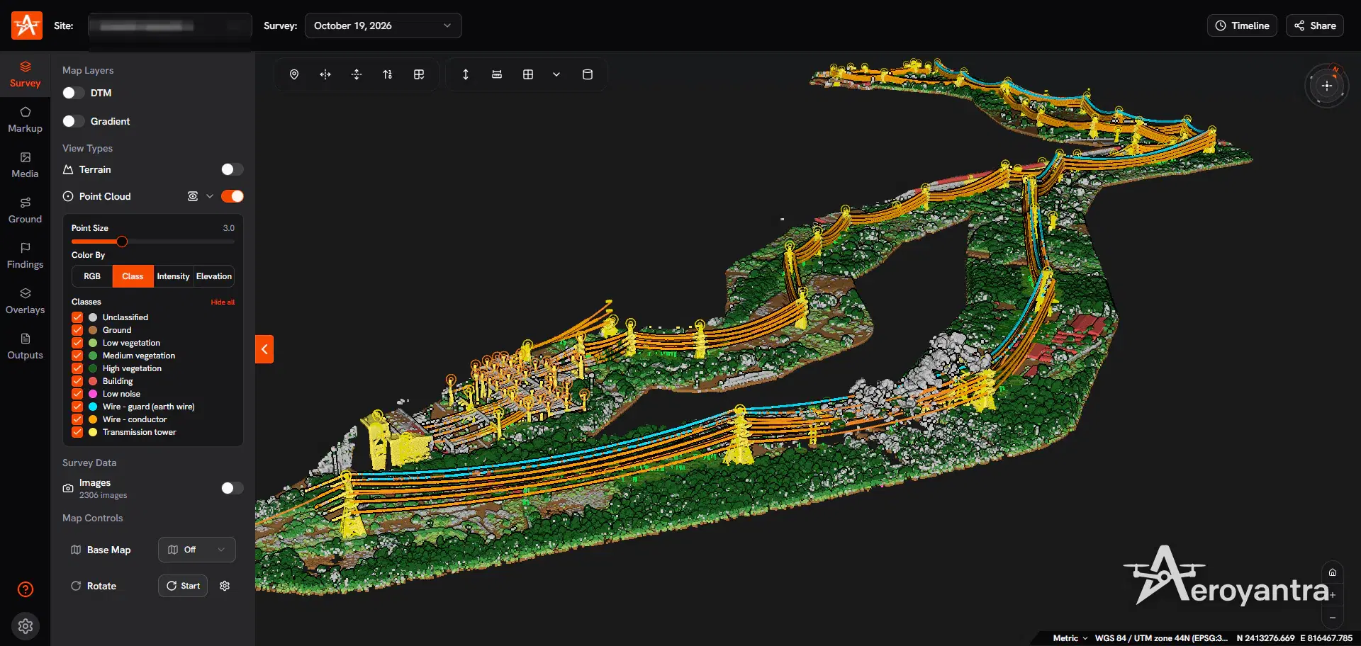
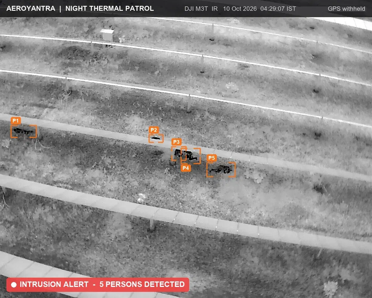
Night thermal drone frame at 04:29 IST: five intruders tagged P1 to P5 crouched under a solar module row - solar plant night thermal patrolClassified point cloud of corridor assets, conductors and earth wire - transmission corridor asset mapping, lidar
Real night patrol | five intruders tagged at 04:29 IST
3+
cities
2
services

Explore drone survey services and aerial mapping across Odisha. Browse available drone surveying and mapping services and select your city from Bhubaneswar, Rourkela, Angul to view detailed local service information.

Most Requested Drone Mapping Services in Odisha

Popular drone survey and aerial mapping services available across multiple cities in Odisha.

Night thermal drone frame at 04:29 IST: five intruders tagged P1 to P5 crouched under a solar module row - solar plant night thermal patrol

Real night patrol | five intruders tagged at 04:29 IST

Drone Surveillance

Drone Surveillance in Odisha

Night thermal drone patrols that catch cable and material theft at solar plants and industrial sites, with WhatsApp alerts and an evidence pack for every incident. Available in 3 cities across Odisha.

3 cities
Night thermal patrolsWhatsApp alertsEvidence pack
Classified point cloud of corridor assets, conductors and earth wire - transmission corridor asset mapping, lidar

LiDAR survey | classified point cloud of a transmission corridor

LiDAR Survey

LiDAR Survey in Odisha

Bare-earth terrain capture and classified point clouds for vegetated, difficult, or corridor-heavy sites that need higher-confidence elevation data. Available in 3 cities across Odisha.

3 cities
Point cloudBare-earth DTMCorridor surfaces

Why Choose Aeroyantra Drone Survey Services in Odisha

Professional drone surveying and mapping services with comprehensive aerial survey coverage across Odisha.

Comprehensive Service Coverage

Access detailed information about drone survey services and aerial mapping available in your city and across the state.

Multiple Service Categories

Wide range of specialized drone mapping and surveying services tailored to different industry needs.

Easy Navigation

Find the right service for your location quickly with our organized state and city pages.

City Drone Survey Service Hubs in Odisha

Expand a city to view all available drone surveying and mapping services in that location.

Angul

Drone SurveillanceLiDAR Survey

Bhubaneswar

Drone SurveillanceLiDAR Survey

Rourkela

Drone SurveillanceLiDAR Survey

Odisha Coverage FAQs

Which cities in Odisha does Aeroyantra serve?

Aeroyantra currently provides drone survey services across 3 cities in Odisha, including Bhubaneswar, Rourkela, Angul. Each city has dedicated service information tailored to local requirements.

Which services are most prominent in Odisha?

The most requested services in Odisha include Drone Surveillance, LiDAR Survey. Browse our service categories to find detailed information about each offering.

How can I find the right service for my project in Odisha?

Start by selecting the service category that matches your project needs, then choose your city to view specific service details, deliverables, workflows, and pricing information.

Planning Survey Work in Odisha?

Share your project location, scope, and requirements. We will recommend the best drone survey solution for your needs.

Professional consultation
Customized service recommendations
48-72 hour delivery windows
DGCA-certified field workflows

Trusted by teams in construction, mining, energy & infrastructure

  • ITC logo
  • Greenko logo
  • Proterra Outdoor Design logo
  • Begrar Group GmbH logo
  • Petagma logo
  • 33Visual logo
Read client stories