Drone Survey for Smart Cities | GIS & Digital Twin
Aerial mapping for smart city and urban works. GIS data capture, digital twin creation, and infrastructure monitoring with 2-5 cm accuracy.
Drone Survey for Smart Cities | GIS & Digital Twin
Aerial mapping for smart city and urban works. GIS data capture, digital twin creation, and infrastructure monitoring with 2-5 cm accuracy.
Table Of Content
- Smart City Drone Mapping and Aerial Survey & LiDAR for Urban Planning, GIS, and Digital Twins
- Urban Planning Runs on Data That Is Outdated Before the Project Starts
- Survey-Grade Drone Mapping and LiDAR Survey Intelligence Built for Complex Urban Environments
- Accurate Urban Baselines and Topographical Survey for Master Plans, Zoning, and Development Approvals
- Urban Land Use Monitoring: Know What Is on the Ground. Know When It Changed.
- Urban Infrastructure Development and Monitoring
- LiDAR for Smart Cities - 3D Urban Intelligence Beyond What Cameras Capture
- Built for City Modernization Programs and Urban Development Authority Requirements
- Complete Deliverables for Urban Projects
- Who Uses Aeroyantra for Smart City and Urban Planning Projects
- Frequently Asked Questions
- Ready to Get Started?
Smart City Drone Mapping and Aerial Survey & LiDAR for Urban Planning, GIS, and Digital Twins
Urban planning decisions made on outdated satellite imagery, inconsistent ground surveys, and manually assembled GIS data produce infrastructure that does not match design intent - and cities that cost more to operate than they should.
Aeroyantra is a smart city drone mapping and LiDAR survey platform built for urban planning, GIS base mapping, land use monitoring, and digital twin development. Aeroyantra delivers survey-grade drone surveying and mapping, aerial drone survey, and LiDAR for smart city planning, land use monitoring, urban infrastructure development, and municipal works using aerial survey drone technology and drone lidar mapping - giving planners, agencies, and contractors the accurate, current spatial data that every urban decision depends on using our drone mapping services and aerial photogrammetry.
Urban Planning Runs on Data That Is Outdated Before the Project Starts
Urban planning decisions made on outdated satellite imagery, inconsistent ground surveys, and manually assembled GIS data produce infrastructure that does not match design intent - and cities that cost more to operate than they should.
The consequences are predictable:
-
Master plans built on inaccurate baselines - Zoning decisions, density calculations, and infrastructure routing based on satellite imagery that does not reflect current ground conditions
-
Land use disputes that delay approvals - Encroachment detection and boundary verification that cannot be resolved without current, authoritative aerial data
-
Infrastructure that misses design intent - Roads, drains, utilities, and public works built without accurate terrain data produce rework, flooding, and maintenance failures
-
Regulatory documentation assembled reactively - Environmental clearances, compliance submissions, and project records built from incomplete field data that does not hold up to scrutiny
-
No time-series record of urban change - Without consistent aerial monitoring, cities cannot measure growth, track encroachment, or demonstrate compliance over time
The problem is not a lack of planning. It is a lack of accurate, current, georeferenced spatial data at the resolution that urban decisions require.
Survey-Grade Drone Mapping and LiDAR Survey Intelligence Built for Complex Urban Environments
Aeroyantra delivers drone mapping and LiDAR survey workflows purpose-built for the complexity of urban environments using aerial survey drone technology and drone surveying and mapping - dense built fabric, mixed land use, rapid development cycles, and regulatory documentation requirements that demand accuracy and traceability.
With RTK, PPK, and GCP-supported workflows, Aeroyantra achieves 2-3 cm horizontal accuracy and vertical precision suitable for urban planning, infrastructure design, and compliance documentation. Our drone mapping services and UAV mapping services provide comprehensive aerial mapping software, drone 3d mapping, and GIS mapping solutions.
What that means for urban projects:
-
Current, accurate baselines - Orthomosaics and 3D models captured at the resolution urban planning decisions require, updated as frequently as the project demands
-
Land use data you can act on - Georeferenced land use classification, encroachment detection, and boundary verification from aerial data - not outdated records
-
Infrastructure design support - Accurate terrain, drainage, and utility data for road design, stormwater planning, and service routing
-
Compliance-ready documentation - Georeferenced, time-stamped records suitable for regulatory submissions, environmental clearances, and audit requirements
-
GIS-compatible outputs - All deliverables compatible with ArcGIS, QGIS, AutoCAD Civil 3D, and standard municipal GIS platforms
-
Browser-based stakeholder access - Share 3D city models and orthomosaics with planning committees, elected officials, and public consultees - no software installation required
Accurate Urban Baselines and Topographical Survey for Master Plans, Zoning, and Development Approvals
Master plans and development approvals built on inaccurate spatial data produce infrastructure mismatches that compound over decades. A road alignment based on a 2-meter-accuracy satellite image produces a different outcome than one based on 3-centimeter drone survey data. At urban scale, that difference is measured in significant rework costs.
This provides municipalities and development authorities with survey-grade urban GIS base maps instead of outdated satellite imagery. Aeroyantra delivers the accurate, current spatial baseline that urban planning decisions require.
What Aeroyantra delivers for urban planning:
-
High-resolution orthomosaic - True-color aerial imagery at 1-3 cm/pixel covering the full planning area, suitable for master plan base mapping and public consultation materials
-
Digital Terrain Model (DTM) - Bare-earth surface model for drainage design, flood risk assessment, and infrastructure routing
-
Digital Surface Model (DSM) - Full surface capture including buildings, vegetation, and structures for density analysis and shadow/wind modeling
-
3D city model - Photogrammetric or LiDAR-derived 3D model of the urban area for visualization, planning simulation, and stakeholder engagement
-
Contour mapping - Engineering-grade contour data at user-defined intervals for site grading, drainage design, and topographic analysis
-
Building footprint extraction - Automated extraction of building outlines and heights from 3D model data for GIS integration and planning databases
-
Green space and vegetation mapping - Identification and classification of urban green cover, tree canopy, and open space for planning and environmental compliance
-
Flood risk and drainage basin analysis - Terrain-derived catchment analysis and drainage flow modeling for stormwater infrastructure planning
Urban Land Use Monitoring: Know What Is on the Ground. Know When It Changed.
Land use monitoring is one of the most resource-intensive and legally consequential activities in urban governance. Manual field surveys are slow, inconsistent, and difficult to defend in a dispute. Satellite imagery lacks the resolution to distinguish encroachment from legitimate development at the parcel level.
This creates a time-series urban change detection and encroachment monitoring system from drone survey data. Drone mapping gives municipal bodies and development authorities a current, defensible, georeferenced record of land use and encroachment - updated as frequently as governance requires.
What Aeroyantra delivers for land use monitoring:
-
Land use classification mapping - Automated and manually verified classification of land use categories - residential, commercial, industrial, agricultural, open space, water bodies - from high-resolution aerial imagery
-
Encroachment detection - Identification of unauthorized structures, boundary violations, and land use changes against approved plans and previous survey records
-
Time-series change detection - Repeat surveys registered to a common datum, enabling detection of new construction, demolition, vegetation change, and land use conversion between monitoring cycles
-
Boundary and cadastral verification - Aerial verification of plot boundaries and cadastral records against ground conditions, supporting land records modernization programs
-
Illegal construction identification - Detection of unauthorized construction activity in restricted zones, green belts, floodplains, and notified areas
-
Slum and informal settlement mapping - High-resolution mapping of informal settlements for rehabilitation planning, infrastructure provisioning, and tenure regularization programs
-
Agricultural land conversion monitoring - Detection of agricultural land conversion to non-agricultural use in peri-urban zones for regulatory compliance
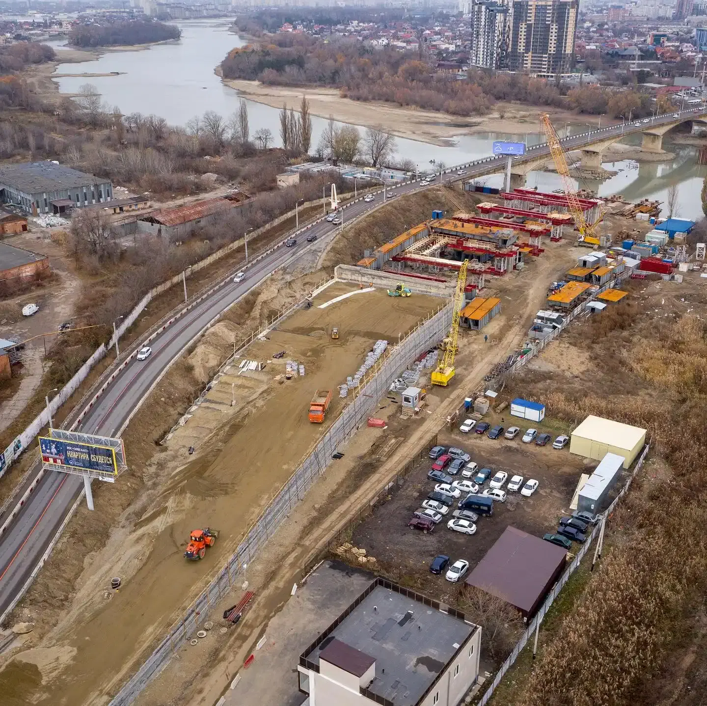
Urban Infrastructure Development and Monitoring
Infrastructure That Matches Design Intent - From Survey to Handover
Urban infrastructure projects - roads, drains, water supply networks, public spaces, and civic facilities - fail their design intent when the spatial data underpinning them is inaccurate. Aeroyantra supports the full infrastructure development lifecycle from pre-construction survey to as-built verification.
Road and Drainage Infrastructure
-
Pre-construction topographic survey - Accurate terrain baseline for road alignment design, drainage gradient calculation, and utility conflict identification
-
Construction progress monitoring - Weekly aerial updates showing road formation, drainage installation, and earthwork progress against design
-
Pavement condition assessment - High-resolution aerial imagery for surface condition mapping, pothole detection, and maintenance prioritization across the road network
-
Stormwater drainage mapping - Identification and profiling of drainage channels, culverts, and outfalls for network planning and flood risk management
-
Road network geometry verification - As-built road alignment, width, and gradient verification against design drawings before handover
Water Supply and Utility Infrastructure
-
Pipeline route survey - Accurate terrain and land use data for water supply, sewerage, and utility corridor planning
-
Utility mapping before backfill - Georeferenced record of utility installations before trenches are closed, preserved in the project as-built package
-
Water body and reservoir mapping - High-resolution mapping of lakes, ponds, tanks, and reservoirs for water resource planning and encroachment monitoring
Public Spaces and Civic Infrastructure
-
Park and open space planning - Accurate terrain and vegetation data for landscape design, drainage, and public space layout
-
Heritage structure documentation - High-resolution photogrammetric documentation of heritage buildings and precincts for conservation planning and regulatory records
-
Public facility site assessment - Pre-construction site surveys for schools, hospitals, community centers, and civic facilities
LiDAR for Smart Cities - 3D Urban Intelligence Beyond What Cameras Capture
Urban LiDAR takes city mapping from surface imagery to full three-dimensional spatial intelligence. Where photogrammetry captures what is visible, LiDAR captures the geometry of everything - including what is beneath tree canopy, inside dense built fabric, and at the precise elevations that drainage and infrastructure design require.
LiDAR-derived 3D city models form the geometric foundation for smart city digital twins and urban analytics platforms. Aeroyantra supports LiDAR workflows for urban environments where photogrammetry alone cannot deliver the required precision or penetration.
What Aeroyantra Delivers from Urban LiDAR Surveys
-
High-density point cloud - 100+ points per square meter across the urban survey area, capturing building geometry, road surfaces, vegetation, and terrain in a single dataset
-
Bare-earth DTM under canopy - Ground surface model derived by filtering vegetation and structures from the point cloud - essential for drainage design in tree-covered urban areas
-
Building height and volume extraction - Precise building heights and volumetric data from classified point cloud, supporting density analysis, shadow modeling, and urban heat island assessment
-
3D building model generation - LoD2 and LoD3 building models extracted from LiDAR data for urban digital twin applications and BIM integration
-
Road surface condition mapping - Millimeter-level road surface geometry for pothole detection, camber analysis, and pavement management
-
Tree canopy height and coverage mapping - Precise canopy height models and coverage percentages for urban forestry planning and green infrastructure assessment
-
Facade and streetscape documentation - Mobile or drone LiDAR capture of building facades and streetscapes for heritage documentation, retail planning, and public realm design
-
Underground utility conflict analysis - LiDAR terrain data combined with utility records to identify potential conflicts before excavation
-
Flood modeling and inundation analysis - High-accuracy terrain data for hydraulic modeling, flood risk assessment, and climate resilience planning
-
Digital twin data layer - LiDAR point cloud and derived 3D models as the geometric foundation for smart city digital twin platforms
Built for City Modernization Programs and Urban Development Authority Requirements
Aeroyantra is aligned with spatial data requirements for city modernization programs, infrastructure upgrade initiatives, and urban development authority projects.
Municipal departments, planning agencies, and development authorities working under these programs require:
- Accurate GIS base maps for project planning and monitoring
- Land use and encroachment data for regularization and compliance
- Infrastructure progress documentation for agency and program reporting
- Environmental and regulatory compliance records
- Stakeholder-ready visualization for public consultation and elected body review
Aeroyantra delivers all of these from a single aerial data platform, with outputs formatted for integration into municipal and enterprise GIS systems.
Typical program alignment:
-
City modernization programs - GIS base mapping, 3D city modeling, infrastructure monitoring, and digital twin data layers for command center integration
-
Water and sewerage upgrade programs - Network surveys, urban flooding assessment, and infrastructure progress documentation
-
Affordable housing initiatives - Settlement mapping, land availability assessment, and housing project progress monitoring
-
Urban development authorities - Master plan base mapping, land use monitoring, encroachment detection, and development approval support
Complete Deliverables for Urban Projects
| Deliverable | Planning | Land Use | Infrastructure | LiDAR | Compliance |
|---|---|---|---|---|---|
| High-res orthomosaic | Yes | Yes | Yes | Yes | Yes |
| Digital Terrain Model (DTM) | Yes | - | Yes | Yes | Yes |
| Digital Surface Model (DSM) | Yes | Yes | Yes | - | Yes |
| 3D city model | Yes | - | - | Yes | - |
| Land use classification map | - | Yes | - | - | Yes |
| Change detection report | - | Yes | Yes | - | Yes |
| Encroachment detection report | - | Yes | - | - | Yes |
| LiDAR point cloud (LAS/LAZ) | - | - | - | Yes | Yes |
| Building height extraction | Yes | - | - | Yes | - |
| Road condition assessment | - | - | Yes | Yes | - |
| Flood risk terrain model | Yes | - | Yes | Yes | - |
| Digital twin data layer | - | - | - | Yes | - |
| Time-series progress record | - | Yes | Yes | - | Yes |
| GIS-compatible exports | Yes | Yes | Yes | Yes | Yes |
Who Uses Aeroyantra for Smart City and Urban Planning Projects
Aeroyantra is used by urban planners, municipal engineers, development authority teams, and infrastructure contractors managing:
- City modernization project planning and monitoring
- Municipal GIS base mapping and update programs
- Development authority master plan preparation and revision
- Land records modernization and encroachment detection programs
- Urban infrastructure construction - roads, drains, water supply, public spaces
- Affordable housing and rehabilitation project planning
- Environmental compliance and regulatory documentation for urban projects
- Heritage conservation documentation and planning
- Flood risk assessment and climate resilience planning
- Urban digital twin platform data provisioning
Frequently Asked Questions
Q1: How is drone mapping better than satellite imagery for urban planning?
Satellite imagery used for urban planning typically has a resolution of 30-50 cm at best, and is often months or years out of date by the time it reaches a planning team. Aeroyantra drone surveys deliver 1-3 cm/pixel resolution on demand, capturing current ground conditions at the precision that zoning decisions, encroachment detection, and infrastructure design require. For any decision where parcel-level accuracy matters, drone mapping is not a replacement for satellite imagery - it is a fundamentally different class of data.
Q2: Can Aeroyantra data be integrated into our existing municipal GIS system?
Yes. Aeroyantra exports all deliverables in formats compatible with standard municipal GIS platforms - GeoTIFF for raster data, SHP and GeoJSON for vector data, and LAS/LAZ for point clouds. Outputs are compatible with ArcGIS, QGIS, and other municipal or enterprise GIS platforms.
Q3: How frequently should urban areas be surveyed for land use monitoring?
For active urban fringe areas experiencing rapid development, quarterly surveys are standard for encroachment detection and land use change monitoring. For stable inner-city areas, annual surveys are typically sufficient for GIS base map maintenance. For infrastructure projects under active construction, monthly or bi-monthly surveys are recommended for progress documentation and compliance reporting.
Q4: Can Aeroyantra detect unauthorized construction and encroachment from drone data?
Yes. Change detection workflows compare current survey data against a baseline orthomosaic or approved plan layer. New construction, boundary violations, and land use changes are automatically flagged and georeferenced for field verification. The output is a defensible, time-stamped aerial record that can support enforcement action and regulatory proceedings.
Q5: What is a 3D city model and how is it used in urban planning?
A 3D city model is a georeferenced three-dimensional representation of the urban environment - buildings, roads, vegetation, and terrain - derived from drone photogrammetry or LiDAR data. It is used for shadow and sunlight analysis, wind corridor modeling, density visualization, flood simulation, and public consultation. Aeroyantra produces 3D city models at LoD1 to LoD3 detail levels depending on project requirements, compatible with standard urban planning and BIM platforms.
Q6: Can Aeroyantra support smart city digital twin requirements?
Yes. LiDAR-derived 3D city models and classified point clouds from Aeroyantra form the geometric foundation layer for smart city digital twin platforms. Outputs are compatible with common digital twin and command center integration formats. Aeroyantra can provide repeat survey cycles to keep the digital twin current as the city develops.
Q7: How does Aeroyantra handle regulatory compliance for urban drone operations?
All Aeroyantra operations are conducted in compliance with applicable civil aviation regulations and airspace permissions for the project location. Urban operations in controlled and restricted airspace require prior authorization through the relevant aviation platform. Coordination with local aviation authorities, municipal bodies, and security agencies is handled with the client's operational team. Aeroyantra provides technical support for flight planning within approved operational parameters.
Q8: What area can Aeroyantra cover in a single day for urban mapping?
For photogrammetry at 3-5 cm GSD, a single drone can cover 5-15 sq km per day in urban environments depending on airspace restrictions, obstacle density, and flight altitude. For LiDAR surveys, coverage of 3-8 sq km per day is typical in dense urban areas. Multi-drone deployments are available for large city-scale mapping programs requiring faster data acquisition.
Ready to Get Started?
Whether you are planning a new smart city project, monitoring land use changes, or developing urban infrastructure, Aeroyantra gives your team the spatial data foundation that every urban decision depends on.
Other Industries We Serve
Discover how Aeroyantra delivers survey-grade drone mapping across different sectors
Mining & Quarrying
Stockpile volumes, pit progression, and compliance documentation
Construction
Earthworks monitoring, cut/fill analysis, and as-built verification
Roads & Highways
Corridor mapping, alignment verification, and progress tracking
Rail & Linear Infrastructure
Corridor monitoring, embankment tracking, and ROW verification
Industrial & EPC
Site planning, structural inspection, and facility documentation
Waste Management
Landfill volume tracking, cell progression, and compliance
Agriculture
Precision farming, crop monitoring, and irrigation planning
Oil & Gas
Pipeline monitoring, facility inspection, and thermal imaging
Solar
Panel inspection, performance monitoring, and hot spot detection
Owners & Developers
Independent progress verification and quantity validation