Drone Survey for Roads | Corridor Mapping & Cut/Fill
Aerial survey for road and highway projects. Corridor mapping, LiDAR, cut/fill analysis, and alignment verification for NHAI and state highway works.
Drone Survey for Roads | Corridor Mapping & Cut/Fill
Aerial survey for road and highway projects. Corridor mapping, LiDAR, cut/fill analysis, and alignment verification for NHAI and state highway works.
Table Of Content
- Road & Highway Drone Survey and Aerial Mapping for Corridor Mapping, Cut/Fill Analysis, and Alignment Verification
- Road Projects Lose Margin at the Same Three Points. Every Time.
- Survey-Grade Drone Mapping and Aerial Drone Survey Data Across Every Phase of Road and Highway Construction
- Start With an Accurate Road Corridor Baseline - Not a Design Assumption
- Measure What Moved. Validate Before Billing. End Quantity Disputes.
- Weekly Corridor Progress Data Your Project Team Can Actually Use
- LiDAR for Road and Highway Corridors - Precision Where Photogrammetry Has Limits
- Catch Road Alignment Deviations Before Compaction. Not After.
- Bridges, Culverts, and Drainage - Documented at Every Construction Phase
- As-Built Documentation That Holds Up to Client and NHAI Scrutiny
- Photogrammetry or LiDAR - Choosing the Right Workflow for Your Corridor
- Complete Deliverables by Project Phase
- Who Uses Aeroyantra for Road and Highway Corridor Projects
- Frequently Asked Questions
- Ready to Close the Quantity Gap on Your Road or Highway Project?
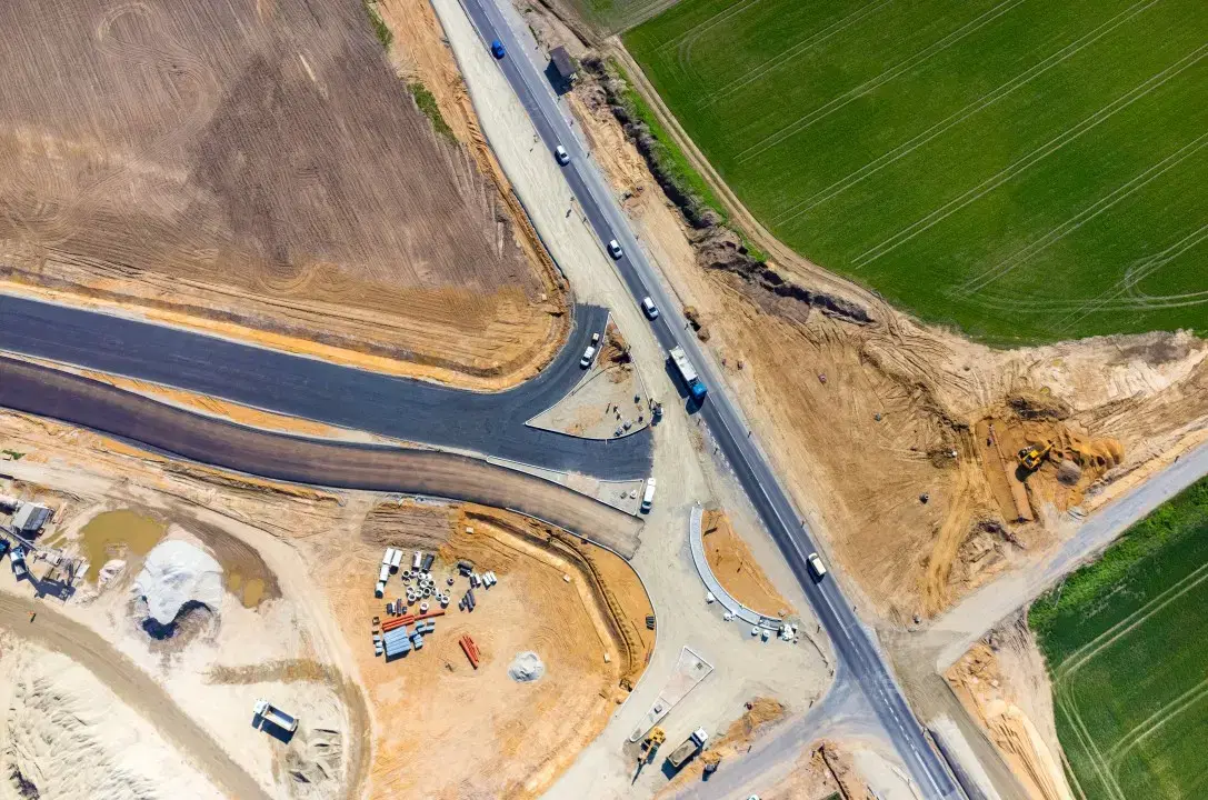
Road & Highway Drone Survey and Aerial Mapping for Corridor Mapping, Cut/Fill Analysis, and Alignment Verification
Road and highway projects lose margin the same way every time - earthwork quantities disputed at billing, alignment deviations caught after compaction, and progress reports that do not reflect what is actually on the ground.
Aeroyantra is a road and highway drone survey and LiDAR survey corridor mapping platform built for earthwork validation, alignment verification, and audit-ready project documentation. Aeroyantra delivers survey-grade drone surveying and mapping, aerial drone survey, and LiDAR for road and highway construction - cut/fill analysis, earthwork validation, corridor mapping, progress tracking, and as-built verification across every phase of the project lifecycle using our drone mapping services and aerial survey drone technology.
Road Projects Lose Margin at the Same Three Points. Every Time.
Road and highway construction is one of the most data-intensive project types in infrastructure - and one of the most consistently under-measured. The gap between what was designed, what was built, and what was measured produces cost overruns that repeat across projects regardless of contractor experience or project scale.
The pattern is consistent:
-
Earthwork quantity disputes arise because volumes were estimated from cross-sections, not measured from the ground as it was actually cut and filled
-
Alignment deviations go undetected until subgrade preparation is complete, compaction is done, and corrective work requires breaking finished layers
-
Progress reporting is subjective because site visits cover a fraction of a multi-kilometer corridor and ground-level visibility is inherently limited
-
Billing cycle reconciliation fails because the quantity data submitted by the contractor and verified by the engineer were measured differently, at different times, using different methods
-
As-built documentation is assembled reactively from incomplete field records that do not reflect what was actually constructed
-
Haul route optimization is guesswork because cut-and-fill balance calculations are based on design cross-sections rather than measured terrain
By the time any of these problems surface in a project review, the cost of correction has compounded beyond what a single survey cycle would have cost to prevent.
Survey-Grade Drone Mapping and Aerial Drone Survey Data Across Every Phase of Road and Highway Construction
Aeroyantra delivers drone mapping and LiDAR survey workflows that produce engineering-grade outputs at every project phase - from pre-construction topographic baseline to final as-built corridor record using aerial photogrammetry and drone lidar mapping.
With RTK, PPK, and GCP-supported workflows, Aeroyantra achieves 2-3 cm horizontal accuracy and vertical precision suitable for earthwork validation, alignment monitoring, and quantity reconciliation across road corridors of any length and complexity. Our drone surveying and mapping services and UAV mapping services provide comprehensive aerial mapping solutions.
What that means across the project lifecycle:
-
Pre-construction - Accurate topographic baseline, corridor alignment support, and bid verification before ground-break
-
Earthworks phase - Real-time cut/fill tracking, quantity validation tied to billing cycles, and haul route optimization
-
Subgrade and pavement phase - Alignment deviation detection before critical layers are placed, level verification, and compaction area documentation
-
Structures phase - Bridge and culvert progress monitoring, embankment condition tracking, and structural geometry verification
-
Closeout - Comprehensive as-built corridor documentation formatted for client handover and regulatory submission
Start With an Accurate Road Corridor Baseline - Not a Design Assumption
Road alignment decisions made on inaccurate topographic data produce earthwork imbalances, drainage failures, and structure conflicts that compound through every subsequent phase. A 10 cm vertical error in a pre-construction survey translates to significant earthwork quantity variance across a multi-kilometer corridor.
Aeroyantra delivers pre-construction topographical survey data that give road project teams an accurate, georeferenced baseline before a single machine moves.
What Aeroyantra delivers for pre-construction road surveys:
-
High-resolution orthomosaic - True-color aerial imagery of the full corridor at 1-3 cm/pixel, suitable for alignment planning, land acquisition documentation, and stakeholder review
-
Digital Terrain Model (DTM) - Bare-earth surface model for road design, drainage gradient calculation, and earthwork balance optimization
-
Digital Surface Model (DSM) - Full surface capture including existing structures, vegetation, and utilities for conflict identification
-
Corridor contour mapping - Engineering-grade contour data at user-defined intervals for horizontal and vertical alignment design
-
Cross-section generation - Design cross-sections extracted from DTM data at user-defined chainages for earthwork quantity estimation and design validation
-
Existing structure and utility mapping - Georeferenced record of existing structures, utility crossings, and drainage features within the corridor
-
Cut-and-fill balance calculation - Pre-construction earthwork optimization to minimize haul distances and material import/export costs
-
Land acquisition support - High-resolution aerial imagery and boundary data for land acquisition documentation and dispute resolution
-
Bid verification surveys - Accurate quantity and condition data before contract award, reducing bid risk for contractors and clients
Technical Performance:
| Parameter | Specification |
|---|---|
| Georeferencing | RTK, PPK, GCP-supported |
| Horizontal accuracy | 2-3 cm under proper survey standards |
| Vertical accuracy | Suitable for road design and earthwork calculation |
| Cross-section interval | User-defined - typically 10-25 m for road design |
| Coverage rate | 20-50 km of corridor per day |
| Output formats | GeoTIFF, DXF, SHP, LAS - compatible with AutoCAD Civil 3D, Bentley OpenRoads, ArcGIS |
Measure What Moved. Validate Before Billing. End Quantity Disputes.
Earthwork is where road projects most consistently lose margin - and where drone data delivers the clearest, fastest return on investment.
Manual cross-section methods introduce earthwork quantity variance of 5-15% on large road packages. That variance translates directly into billing disputes, contractor claims, and project delays. On a 100 km highway project, a 10% quantity variance is not a rounding error - it is a significant dispute.
This replaces traditional cross-section methods with continuous corridor-scale surface measurement from drone survey and LiDAR data. Aeroyantra replaces cross-section estimation with measured drone 3d mapping surface comparison from aerial drone survey data.
How Cut/Fill Analysis Works
Each drone survey produces a Digital Surface Model of the corridor that is compared against the previous survey and the design model. The result is a quantified cut-and-fill report showing exactly how much material was cut, how much was filled, where it moved from and to, and whether the earthwork matches design intent - before billing cycles close.
What Aeroyantra delivers for cut/fill analysis:
-
Cut volume quantification - Precise measurement of material removed from cut areas, by chainage and by total corridor
-
Fill volume quantification - Precise measurement of material placed in fill areas, with compaction factor analysis against design assumptions
-
Net earthwork balance - Cut-minus-fill balance calculation across the full corridor for haul optimization and import/export planning
-
Design-to-actual comparison - Current earthwork surface compared against design subgrade levels to identify areas ahead of or behind design intent
-
Haul route optimization data - Spatial cut-and-fill distribution data for optimizing material movement and reducing haul distances
-
Billing cycle reconciliation - Survey-cycle volume reports tied to billing milestones, providing an independent measurement basis for contractor payment verification
-
Borrow pit and spoil area monitoring - Volume tracking of material sources and disposal areas alongside the main corridor survey
Weekly Corridor Progress Data Your Project Team Can Actually Use
Progress meetings on road projects run on subjective site visit reports, manually updated chainage records, and percentage completion estimates that nobody can verify. Aeroyantra replaces subjective reporting with georeferenced, time-stamped aerial data that shows exactly what was built, where, and when - across the full corridor length.
This creates a time-series road corridor monitoring record that can be used for billing, claims, and compliance reporting.
What Aeroyantra delivers for progress monitoring:
-
Weekly or bi-weekly orthomosaic updates - Current corridor condition captured and processed within 24-48 hours of flight, covering the full project length in a single mission
-
Chainage-by-chainage progress breakdown - Quantified progress status at defined chainage intervals, replacing subjective percentage estimates with measured data
-
Time-series corridor comparisons - Repeat surveys registered to a common datum, enabling side-by-side comparison of corridor evolution across the project timeline
-
Design overlay analysis - Current earthwork and pavement status compared against design drawings and project schedule to identify areas ahead of or behind programme
-
Milestone documentation - Georeferenced, time-stamped aerial records at every project milestone for contractual, regulatory, and client reporting
-
Structures progress tracking - Bridge, culvert, and drainage structure progress documented alongside corridor earthworks in a single flight
-
Stakeholder reporting packages - Browser-based 3D viewer sharing for remote client and owner access - no software installation required
LiDAR for Road and Highway Corridors - Precision Where Photogrammetry Has Limits
Photogrammetry delivers excellent results on open, well-lit road corridors. But road projects consistently include conditions where photogrammetry falls short - dense tree canopy over the alignment, deep cut sections with shadow zones, bridge structures with complex geometry, and existing road surfaces where texture matching is unreliable.
LiDAR corridor mapping enables accurate DTM generation, road surface geometry capture, and structure documentation even in forested or complex terrain. LiDAR eliminates these limitations. Aeroyantra supports LiDAR workflows for road corridors where photogrammetry accuracy is insufficient or where the deliverable requirements demand the higher precision that only LiDAR can provide.
What Aeroyantra Extracts from LiDAR Road Surveys
-
Bare-earth DTM under canopy - Ground surface model derived by filtering vegetation from the point cloud - essential for alignment design through forested or vegetated corridors
-
Road surface geometry - Millimeter-level road surface capture for camber analysis, rutting detection, pothole mapping, and pavement condition assessment
-
Existing road condition survey - Precise surface condition mapping of existing roads for maintenance prioritization and rehabilitation design
-
Deep cut section geometry - Accurate surface capture in deep cut sections where shadow and occlusion defeat photogrammetry
-
Bridge and structure geometry - Precise 3D capture of bridge decks, abutments, piers, and wing walls for structural assessment and as-built documentation
-
Drainage and culvert mapping - Identification and profiling of drainage channels, culverts, and water crossings along the corridor
-
Slope and embankment stability data - Precise embankment slope geometry for geotechnical assessment and stability monitoring
-
Utility and service crossing detection - Identification of utility crossings and service installations along the corridor for conflict management
-
Retaining wall geometry - Precise capture of retaining wall faces, heights, and alignment for structural verification
-
Time-series change detection - Repeat LiDAR surveys to detect embankment settlement, slope movement, and pavement deformation between monitoring cycles
Catch Road Alignment Deviations Before Compaction. Not After.
Horizontal and vertical alignment deviations on road projects are among the most expensive construction errors to correct - because they are typically detected after compaction, after drainage layers are placed, and sometimes after pavement is laid. At that point, correction means breaking finished work.
Aeroyantra gives road project teams a way to verify subgrade alignment against design intent before each critical layer is placed - catching deviations at the phase where correction costs a fraction of what it costs later.
What Aeroyantra delivers for alignment monitoring:
-
Horizontal alignment verification - Measured road centerline compared against design horizontal alignment, with deviation flagged by chainage
-
Vertical alignment verification - Measured subgrade and formation levels compared against design vertical profile, with cut/fill deviation quantified at each cross-section
-
Cross-fall and camber verification - Measured carriageway cross-fall compared against design parameters for drainage compliance
-
Shoulder and formation width verification - Measured formation width compared against design cross-section at defined chainage intervals
-
Design overlay comparison - Current earthwork surface overlaid against design model with color-coded deviation heatmap showing areas within and outside tolerance
-
Pre-layer placement sign-off data - Survey data captured before each critical layer placement providing an independent record for quality assurance and contractual sign-off
Bridges, Culverts, and Drainage - Documented at Every Construction Phase
Road corridor structures - bridges, culverts, retaining walls, and drainage systems - represent a disproportionate share of project value and a disproportionate share of construction risk. Aeroyantra covers structures alongside corridor earthworks in every survey flight, producing a complete record of structure progress and condition at every monitoring cycle.
What Aeroyantra delivers for structures monitoring:
-
Bridge construction progress - Aerial documentation of pier construction, deck placement, and finishing works at every survey cycle
-
Culvert installation verification - Position, alignment, and invert level verification of culvert installations before backfill
-
Retaining wall progress and alignment - Wall construction progress and face alignment verification against design
-
Embankment condition monitoring - Slope condition, settlement, and erosion monitoring on approach embankments and cut slopes
-
Drainage channel and outlet mapping - Georeferenced record of drainage channel construction, outlet positions, and drainage structure installations
-
Scour and erosion detection - Post-monsoon aerial assessment of scour at bridge foundations, culvert inlets, and drainage outlets
As-Built Documentation That Holds Up to Client and NHAI Scrutiny
Road project as-built documentation assembled from field sketches, contractor-submitted drawings, and manual measurements rarely reflects what was actually constructed. When a client disputes a dimension, or NHAI requires evidence of construction compliance, a document assembled reactively from incomplete records is a liability.
Aeroyantra produces as-built records from aerial and LiDAR data captured throughout the project - not assembled at the end from memory.
What Aeroyantra delivers for as-built verification:
-
Final corridor orthomosaic - Complete aerial record of the finished road at survey-grade accuracy, covering the full corridor length
-
As-built alignment record - Measured horizontal and vertical alignment of the completed road compared against design intent
-
Formation and pavement width verification - Confirmed carriageway, shoulder, and formation widths at defined chainage intervals
-
Structure as-built documentation - Georeferenced record of all structures, drainage installations, and corridor features
-
Design-to-as-built deviation report - Quantified comparison of final construction against design across the full corridor
-
BIM-compatible point cloud and GIS mapping exports - Classified LiDAR point cloud for integration into client BIM environment and GIS mapping platforms
-
Regulatory compliance documentation - Georeferenced, time-stamped records for highway authority and regulatory submission
Photogrammetry or LiDAR - Choosing the Right Workflow for Your Corridor
Both workflows are available through Aeroyantra. The right choice depends on corridor environment, vegetation cover, deliverable requirements, and project phase.
| Factor | Photogrammetry | LiDAR |
|---|---|---|
| Open corridor performance | Excellent | Excellent |
| Canopy penetration | Limited - surface only | Full penetration to bare earth |
| Deep cut section accuracy | Reduced by shadow | Full accuracy |
| Road surface condition | Good | Millimeter-level precision |
| Bridge structure capture | Good | Precise 3D geometry |
| Horizontal accuracy | 2-3 cm (RTK/PPK) | 1-2 cm |
| Coverage rate | 20-50 km/day | 50+ km/day |
| Cost | Lower | Higher |
| Best for | Open corridor earthworks, progress monitoring, quantity validation | Forested corridors, surface condition, structures, as-built precision |
| Combined workflow | Yes - fused dataset available | Yes - geometry + visual context |
For most road corridor projects, Aeroyantra recommends photogrammetry as the standard monitoring workflow with LiDAR deployed at key phases - pre-construction baseline in vegetated terrain, structures documentation, and final as-built record.
Complete Deliverables by Project Phase
| Deliverable | Pre-Construction | Earthworks | Progress | Structures | As-Built |
|---|---|---|---|---|---|
| High-res orthomosaic | ✓ | ✓ | ✓ | ✓ | ✓ |
| Digital Terrain Model (DTM) | ✓ | ✓ | - | - | ✓ |
| Digital Surface Model (DSM) | ✓ | ✓ | ✓ | - | ✓ |
| Cross-section generation | ✓ | ✓ | - | - | ✓ |
| Cut/fill volume report | ✓ | ✓ | - | - | - |
| Design overlay comparison | - | ✓ | ✓ | ✓ | ✓ |
| Alignment deviation report | - | ✓ | ✓ | - | ✓ |
| LiDAR point cloud (LAS/LAZ) | ✓ | - | - | ✓ | ✓ |
| Road surface condition map | - | - | - | - | ✓ |
| Structure progress record | - | - | ✓ | ✓ | ✓ |
| As-built corridor record | - | - | - | - | ✓ |
| Time-series progress archive | - | - | ✓ | ✓ | ✓ |
| GIS and Civil 3D exports | ✓ | ✓ | ✓ | ✓ | ✓ |
Who Uses Aeroyantra for Road and Highway Corridor Projects
Aeroyantra is used by road project contractors, project management consultants, highway authorities, and infrastructure developers managing:
- National highway construction and widening projects
- State highway and district road construction programs
- Expressway and greenfield highway corridor development
- Urban road and flyover construction projects
- Road rehabilitation and resurfacing programs requiring pavement condition data
- Bridge and culvert construction across highway corridors
- Land acquisition survey support for road corridor projects
- Post-construction road condition monitoring and maintenance planning
- EPC project contractors requiring independent quantity verification
Frequently Asked Questions
Q1: How does drone-based cut/fill analysis compare to traditional cross-section methods for road earthworks?
Traditional cross-section methods calculate earthwork volumes from design cross-sections taken at fixed intervals - typically 10-25 m - and assume uniform conditions between sections. Drone survey produces a continuous surface model of the actual ground, with volume calculations derived from the full surface rather than interpolated between sections. For large road packages, this typically reduces earthwork quantity variance from 5-15% with cross-section methods to within 1-2% with drone survey. On a significant highway project, that difference resolves billing disputes before they start.
Q2: How much highway corridor can Aeroyantra cover in a single day?
For photogrammetry at 3-5 cm GSD, a single drone covers 20-50 km of corridor per day depending on flight altitude, corridor width, and site conditions. For LiDAR, coverage of 50+ km per day is achievable on open corridors. Multi-drone deployments are available for projects requiring faster acquisition across very long corridors or tight billing cycle timelines.
Q3: Can Aeroyantra data be used directly in AutoCAD Civil 3D and Bentley OpenRoads?
Yes. Aeroyantra exports DXF, DWG, LAS/LAZ, GeoTIFF, and SHP formats that import directly into AutoCAD Civil 3D, Bentley OpenRoads, and standard GIS platforms. DTM and DSM data can be used as existing ground surfaces in Civil 3D for earthwork calculations, alignment design, and cross-section generation without any conversion or reformatting.
Q4: At what project phases should drone surveys be conducted on a road project?
For maximum value, Aeroyantra recommends surveys at five key phases: pre-construction topographic baseline, earthworks validation tied to billing cycles, subgrade completion before pavement layers are placed, structures milestone documentation, and final as-built closeout. The pre-construction baseline and earthworks monitoring surveys deliver the highest return on investment on most road projects.
Q5: Can drone surveys detect alignment deviations before pavement layers are placed?
Yes. This is one of the highest-value applications of drone survey on road projects. A survey at subgrade completion produces a measured alignment record that can be compared against design intent before any pavement layers are placed. Deviations identified at this stage cost a fraction of what they cost to correct after compaction and pavement placement. Aeroyantra recommends a mandatory survey at subgrade completion on all road projects.
Q6: Can Aeroyantra support highway authority documentation requirements?
Yes. Aeroyantra produces georeferenced, time-stamped aerial records and volume reports that meet the documentation standards required for highway authority project monitoring, compliance submissions, and independent engineer verification. Report formatting can be configured to match specific authority requirements. We recommend confirming format requirements with your project's independent engineer before the first survey cycle.
Q7: How does LiDAR improve road survey accuracy compared to photogrammetry in forested corridors?
In forested or vegetated corridors, photogrammetry captures only the top of the vegetation canopy - not the ground surface beneath it. This makes accurate DTM generation impossible without extensive manual editing, and earthwork calculations based on photogrammetry DTMs in vegetated areas are unreliable. LiDAR penetrates through vegetation to capture the actual ground surface, producing accurate DTMs even in densely forested corridor sections. For any road corridor passing through significant vegetation, LiDAR is the appropriate workflow for pre-construction baseline and earthwork calculation.
Q8: Can Aeroyantra monitor borrow pits and spoil disposal areas alongside the main corridor?
Yes. Borrow pit and spoil area volume tracking is included in standard corridor survey workflows. Each survey flight covers the main corridor and designated borrow/spoil areas, producing volume reports for all areas simultaneously. This gives project teams an independent record of material sourced and disposed, alongside the main corridor earthwork data - critical for quantity reconciliation and environmental compliance.
Ready to Close the Quantity Gap on Your Road or Highway Project?
Whether you are managing pre-construction planning, active earthworks, alignment monitoring, or final as-built documentation, Aeroyantra delivers the aerial corridor data your road project teams need to catch problems at the phase where fixing them is still affordable.
Other Industries We Serve
Discover how Aeroyantra delivers survey-grade drone mapping across different sectors
Mining & Quarrying
Stockpile volumes, pit progression, and compliance documentation
Construction
Earthworks monitoring, cut/fill analysis, and as-built verification
Rail & Linear Infrastructure
Corridor monitoring, embankment tracking, and ROW verification
Industrial & EPC
Site planning, structural inspection, and facility documentation
Waste Management
Landfill volume tracking, cell progression, and compliance
Smart City & Urban Works
Urban planning, land use monitoring, and GIS mapping
Agriculture
Precision farming, crop monitoring, and irrigation planning
Oil & Gas
Pipeline monitoring, facility inspection, and thermal imaging
Solar
Panel inspection, performance monitoring, and hot spot detection
Owners & Developers
Independent progress verification and quantity validation