Road and Highway Corridor Surveys for Alignment, Earthwork, and Billing Control
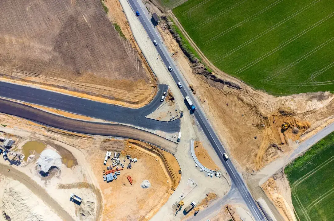
Highway and expressway projects run into delay when cross-sections are outdated, earthwork is billed without independent verification, or corridor documentation fails authority review. Our DGCA-certified survey teams capture linear corridors, interchanges, and structures with drone photogrammetry and LiDAR, then deliver chainage-based outputs for designers, EPC teams, independent engineers, and project owners across India.
Aerial Survey and Drone Mapping Key Capabilities
Corridor Mapping with Aerial Survey Drones
Coverage up to 500m width using aerial drone survey and drone lidar mapping with high-resolution orthomosaic and centerline-ready outputs.
Cross-Sections and Profiles
Cross-sections and longitudinal profiles at the interval your design or IE team needs.
Earthwork Quantities
Cut/fill calculations for planning, billing checks, and execution monitoring.
NHAI and MoRTH Aerial Mapping Documentation
Drone survey services deliverables structured for highway authorities, EPC teams, and independent engineers with aerial surveying and mapping outputs.
Bridge and Flyover Support
Survey support for interchanges, ramps, piers, approaches, and elevated structures.
LiDAR for Complex Corridors
Bare-earth extraction in vegetation or difficult terrain where standard imagery is limited.
NHAI and MoRTH Documentation Support
Georeferenced, time-stamped aerial records and quantity reports built for NHAI packages, independent engineer reviews, EPC billing cycles, and state highway authority submissions.
Highway Project Support
State and Urban Road Programs
We align the report structure before the first survey cycle so the output matches the chainage, quantity, and documentation format expected by your authority or IE team.
Standard Deliverables
Greenfield Alignment, DPR, and Land Interface Surveys
Early-stage corridor surveys reduce redesign and land-interface disputes by giving DPR, design, and acquisition teams a current terrain and access picture before execution starts.
Bridge, Flyover, and Interchange Construction Support
Complex structures need regular aerial records to track ramp geometry, pier progress, embankment shape, and access management across busy urban or intercity work fronts.
LiDAR Survey and Drone 3D Mapping for Road Corridors
Drone-based LiDAR and drone 3D mapping captures bare-earth terrain through dense roadside vegetation, tree cover, and scrub that limits standard photogrammetry — critical for greenfield alignment studies, forested corridor projects, and bridge structure documentation on NHAI, Bharatmala, and state highway projects across India using advanced mapping with drone.
Frequently Asked Questions
Common questions about road and highway corridor surveys
We typically survey corridors up to 500m width, which covers most highway projects including service roads and drainage areas. For wider requirements, we can extend coverage with additional flight planning.