Drone Survey for Industrial & EPC | As-Built & LiDAR
Aerial mapping for industrial and EPC projects. LiDAR, as-built verification, stockpile measurement, and progress tracking with high accuracy.
Drone Survey for Industrial & EPC | As-Built & LiDAR
Aerial mapping for industrial and EPC projects. LiDAR, as-built verification, stockpile measurement, and progress tracking with high accuracy.
Table Of Content
- Industrial & EPC Drone Mapping and Aerial Survey & Reality Capture: Aerial Intelligence from Ground-Break to Handover
- EPC Construction Monitoring: Where Projects Lose Margin and How Drone Data Closes the Gaps
- Survey-Grade Drone Mapping, Aerial Drone Survey, and UAV Mapping Services Across Every Phase of the EPC Project Lifecycle
- Pre-Construction Topographical Survey and Site Mapping: Start Every Project With an Accurate Baseline
- Earthworks & Stockpile Measurement: Measure What Moved. Bill What Was Built.
- Industrial Project Progress Tracking with Weekly Aerial Reality Capture
- LiDAR Structural Inspection for Industrial Projects - Detect Deviations Before They Become Rework
- As-Built Verification & Documentation for Industrial and EPC Projects
- Thermal and Multispectral Drone Inspection for Industrial Sites
- Complete Deliverables by Project Phase
- Who Uses Aeroyantra for Industrial and EPC Projects
- Frequently Asked Questions
- Ready to Close the Data Gap on Your Industrial or EPC Project?
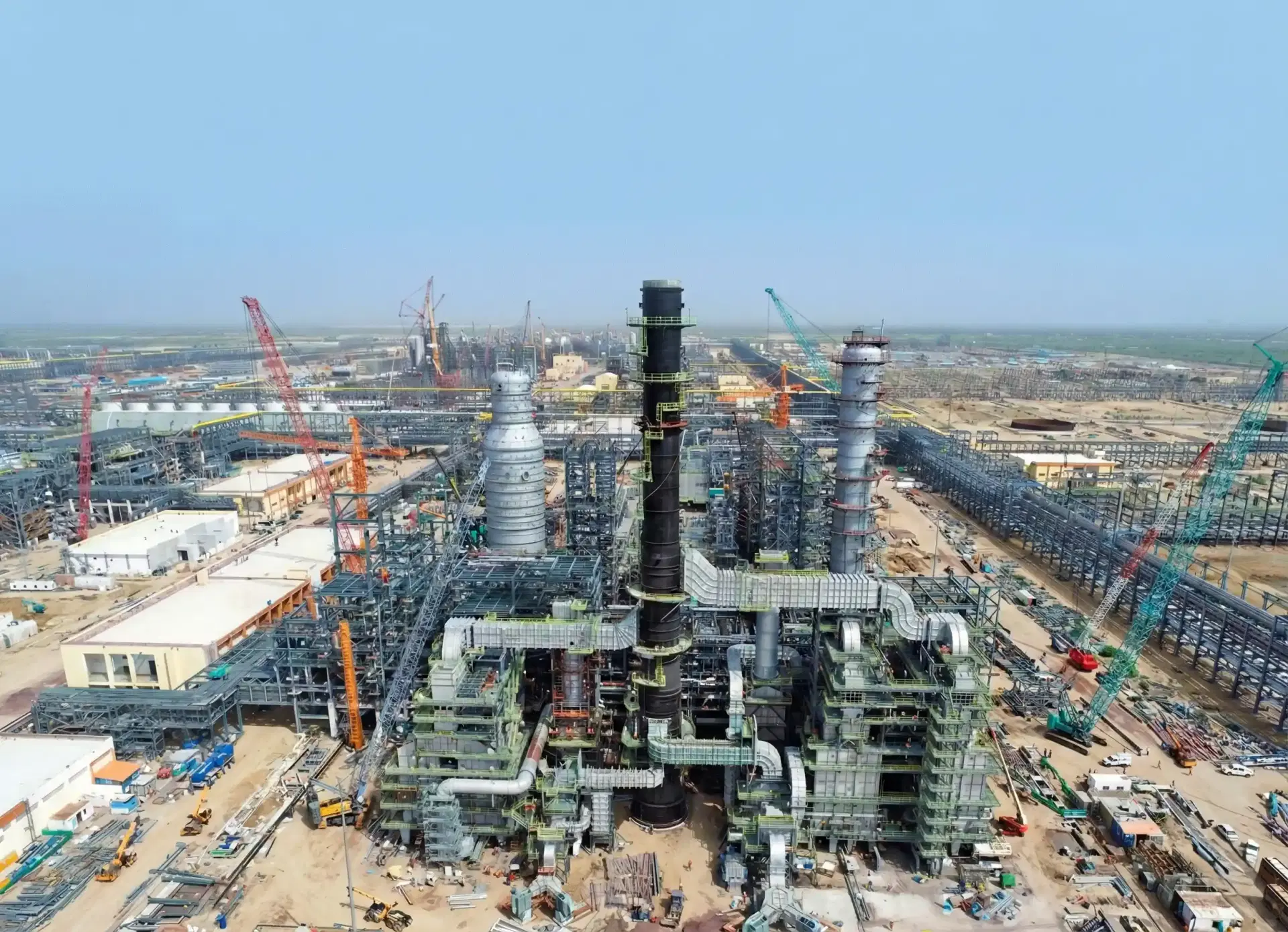
Industrial & EPC Drone Mapping and Aerial Survey & Reality Capture: Aerial Intelligence from Ground-Break to Handover
Aeroyantra is an industrial and EPC drone mapping and reality capture platform that converts aerial imagery and LiDAR survey data into survey-grade surfaces, quantities, and as-built verification datasets. Aeroyantra delivers survey-grade drone surveying and mapping and LiDAR for every phase of industrial construction and EPC project delivery using aerial survey drone technology and drone lidar mapping - from pre-construction site planning to final as-built verification and structural inspection.
EPC projects fail their margins at predictable points: quantity disputes, rework after deviations go undetected, and closeout packages that don't hold up to client scrutiny. Aeroyantra gives your teams the aerial data backbone to catch problems at the phase where fixing them is still cheap using our drone mapping services and aerial photogrammetry.
EPC Construction Monitoring: Where Projects Lose Margin and How Drone Data Closes the Gaps
Most EPC cost overruns are not caused by poor planning. They are caused by a data gap between what was designed, what was built, and what was measured.
The pattern repeats across industrial projects of every scale:
-
Quantity disputes arise because earthwork volumes were estimated, not measured
-
Rework costs accumulate because structural deviations were caught late - after concrete was poured or steel was erected
-
Closeout delays happen because as-built documentation was assembled reactively from incomplete field records
-
Stockpile reconciliation fails because inventory was counted manually and infrequently
-
Progress reporting is subjective because site visits are infrequent and ground-level visibility is limited
By the time any of these problems surface in a project meeting, the cost of correction has already multiplied.
Survey-Grade Drone Mapping, Aerial Drone Survey, and UAV Mapping Services Across Every Phase of the EPC Project Lifecycle
Aeroyantra is not a progress photo tool. It is a structured aerial data platform that produces engineering-grade outputs at every project phase using drone surveying and mapping and aerial photogrammetry - from topographic baseline to final as-built record.
With RTK, PPK, and GCP-supported workflows, Aeroyantra achieves 2-3 cm horizontal accuracy and vertical precision suitable for earthwork validation, structural inspection, and quantity reconciliation across industrial sites of any scale. Our drone mapping services and aerial mapping software provide comprehensive UAV mapping services, drone lidar mapping, and GIS mapping solutions.
What that means across the project lifecycle:
-
Pre-construction - Accurate topographic baseline, site planning data, and bid verification before ground-break
-
Earthworks phase - Real-time cut-and-fill tracking, stockpile measurement, and quantity validation tied to billing cycles
-
Structural phase - Deviation detection against design models before critical work milestones
-
Mechanical and installation phase - Equipment placement verification, utility routing confirmation, and layout compliance
-
Closeout - Comprehensive as-built documentation formatted for BIM, CAD, and client handover packages
Pre-Construction Topographical Survey and Site Mapping: Start Every Project With an Accurate Baseline
Pre-construction decisions made on inaccurate topographic data compound through every subsequent phase. Foundation depths, cut-and-fill balances, drainage design, access road routing - all of these depend on a baseline that is accurate at the centimeter level, not the meter level.
Aeroyantra delivers pre-construction topographic surveys that give EPC teams an accurate, georeferenced baseline before a single machine moves.
What Aeroyantra delivers for site planning:
-
High-resolution orthomosaic - True-color aerial imagery of the site at 1-3 cm/pixel, suitable for layout planning and stakeholder review
-
Digital Terrain Model (DTM) - Bare-earth surface model for earthwork design, drainage analysis, and foundation planning
-
Digital Surface Model (DSM) - Full surface capture including existing structures, vegetation, and site features
-
Contour maps - Engineering-grade contour data at user-defined intervals for design and planning
-
Slope and aspect analysis - Site drainage and stability assessment for layout optimization
-
Existing structure and utility mapping - Georeferenced record of existing site features before demolition or clearance
-
Bid verification surveys - Accurate quantity and condition data before contract award, reducing bid risk
-
Cut-and-fill balance calculation - Pre-construction earthwork optimization to minimize haul distances and material costs
Technical Performance:
| Parameter | Specification |
|---|---|
| Georeferencing | RTK, PPK, GCP-supported |
| Horizontal accuracy | 2-3 cm under proper survey standards |
| Vertical accuracy | Suitable for earthwork and foundation design |
| GSD | 1-3 cm/pixel configurable for site scale |
| Output formats | GeoTIFF, DXF, SHP, LAS - compatible with AutoCAD Civil 3D, Revit, ArcGIS |
Earthworks & Stockpile Measurement: Measure What Moved. Bill What Was Built.
Earthwork is where EPC projects most commonly lose margin - and where construction drone mapping and aerial drone survey data deliver the clearest, fastest return.
Manual volume estimation introduces variance of 5-15% on large earthwork packages. That variance translates directly into billing disputes, contractor claims, and project delays. Aeroyantra replaces estimation with measurement.
This makes Aeroyantra a practical drone 3d mapping system for continuous earthworks monitoring and stockpile measurement across large industrial EPC sites.
Cut-and-Fill Tracking
Each drone survey produces a Digital Surface Model that is compared against the previous survey and the design model. The result is a quantified cut-and-fill report showing exactly how much material moved, where it moved from, and whether grading matches design intent - before billing cycles close.
- Earthwork volumes quantified to within 1% accuracy
- Design-to-actual comparison at every survey cycle
- Haul route optimization data to reduce material movement costs
- Grading compliance verification before concrete or structural work begins
Stockpile Volume Measurement
Industrial sites carry significant material inventory - aggregates, sand, backfill, construction materials - that is routinely under-counted or over-counted using manual methods. Aeroyantra measures stockpile volumes from drone surveys with sub-percent accuracy, replacing manual tape-and-estimate workflows.
- Accurate volumetric measurement of stockpiles of any shape and size
- Inventory reconciliation against delivery and consumption records
- Multi-stockpile site-wide inventory in a single flight
- Time-series tracking of material consumption across the project
Industrial Project Progress Tracking with Weekly Aerial Reality Capture
Progress meetings run on subjective site visit reports and manually updated Gantt charts. Aeroyantra replaces subjective reporting with georeferenced, time-stamped aerial data that shows exactly what was built, where, and when.
What Aeroyantra delivers for progress monitoring:
-
Weekly or bi-weekly orthomosaic updates - Current site condition captured and processed within 24-48 hours of flight
-
Time-series progress comparisons - Repeat surveys registered to a common datum, enabling side-by-side comparison of site evolution across the project timeline
-
Design overlay analysis - Current site condition compared against design drawings to identify areas ahead of or behind schedule
-
Milestone documentation - Georeferenced, time-stamped aerial records at every project milestone for contractual and regulatory purposes
-
Stakeholder reporting packages - Browser-based 3D viewer sharing for remote client and owner access - no software installation required
-
Issue flagging and annotation - Specific areas of concern annotated directly on the aerial dataset for field team follow-up
LiDAR Structural Inspection for Industrial Projects - Detect Deviations Before They Become Rework
Industrial construction involves structures where dimensional tolerance matters: storage tanks, process vessels, chimneys, cooling towers, pipe racks, structural steel frames, and large-span roofs. Deviations from design that go undetected until late in the construction sequence require expensive corrective work - or worse, are handed over to the client and discovered during commissioning.
LiDAR drone inspection enables millimeter-level reality capture for industrial structures where photogrammetry alone is not sufficient. LiDAR drone inspection gives EPC teams a way to verify structural geometry against design models at any point in the construction sequence, without scaffolding, rope access, or service shutdown.
What Aeroyantra Inspects with LiDAR
Storage tanks and process vessels
- Vertical plumb and roundness verification against design geometry
- Settlement monitoring between construction phases
- External surface condition documentation
- Foundation pad level verification
Structural steel and pipe racks
- Column plumb and beam alignment verification
- Connection geometry confirmation before welding or bolting
- Clash detection between structural and mechanical elements
- Deflection monitoring under load
Chimneys, cooling towers, and tall structures
- Vertical alignment and lean measurement
- External surface crack and spalling detection
- Geometric deformation monitoring over time
Industrial buildings and large-span structures
- Roof geometry and drainage verification
- Facade alignment and panel installation confirmation
- Floor level and flatness measurement
Confined spaces and hazardous areas
- Internal inspection of tanks, silos, and vessels without personnel entry
- Structural condition assessment in areas inaccessible to ground crews
- Post-incident damage assessment without exposing inspection teams to risk
The LiDAR Inspection Workflow
1. Mission planning and sensor configuration Flight path planned around structure geometry. Sensor configuration optimized for point density requirements - typically 100+ pts/m2 for structural inspection.
2. Data acquisition Drone captures dense, calibrated point cloud of the structure from multiple angles. Complex structures are covered using multi-pass flight patterns to eliminate occlusion.
3. Point cloud registration and processing Multiple scan passes are registered into a single unified point cloud. Noise filtering and colorization applied using co-registered RGB imagery.
4. Design model comparison Processed point cloud is aligned to the design BIM or CAD model. Deviation analysis produces a color-coded heatmap showing where as-built geometry deviates from design intent, at user-defined tolerance thresholds.
5. Report generation Deviation report delivered with annotated heatmaps, maximum deviation values, and specific areas requiring corrective action - ready for engineer review.
As-Built Verification & Documentation for Industrial and EPC Projects
As-built documentation assembled from field sketches, manual measurements, and contractor-submitted drawings is rarely accurate and rarely complete. When a client disputes a dimension, or a regulator asks for evidence of construction compliance, a document assembled reactively from incomplete records is a liability.
This turns drone reality capture into a defensible as-built verification workflow instead of a last-minute documentation exercise. Aeroyantra produces as-built records from aerial and LiDAR data captured throughout the project - not assembled at the end from memory.
What Aeroyantra delivers for as-built verification:
-
Final orthomosaic and 3D model - Complete aerial record of the finished site at survey-grade accuracy
-
Design-to-as-built deviation report - Quantified comparison of final construction against design intent across the full site
-
Foundation and pad level verification - Confirmed elevation data for all structural foundations and equipment pads
-
Utility and underground service mapping - Georeferenced record of utility routes before backfill, preserved in the as-built package
-
Equipment placement confirmation - Verified position and orientation of major plant and equipment against layout drawings
-
BIM-compatible point cloud - Classified LiDAR point cloud deliverable for integration into the client's BIM environment
-
Regulatory compliance documentation - Georeferenced, time-stamped records suitable for submission to regulatory bodies and client handover packages
Thermal and Multispectral Drone Inspection for Industrial Sites
Structural geometry tells you where things are. Thermal imaging tells you how they are performing.
Aeroyantra supports thermal and multispectral payload integration for industrial inspection workflows where surface condition and thermal performance are as important as dimensional accuracy.
Thermal inspection applications:
-
Electrical panel and switchgear inspection - Hotspot detection at junction boxes, cable trays, and distribution panels without shutdown
-
Roof membrane and insulation inspection - Moisture infiltration and insulation failure detection across large industrial roofs
-
Process pipe and vessel inspection - Thermal anomaly detection at flanges, valves, and insulation damage points
-
Solar installation inspection - Panel-level hotspot and bypass diode failure detection across large industrial solar arrays
-
Refractory and furnace inspection - External thermal mapping of furnace walls and refractory linings to detect hot spots and failure zones
Complete Deliverables by Project Phase
| Deliverable | Pre-Construction | Earthworks | Progress | Structural | Closeout |
|---|---|---|---|---|---|
| High-res orthomosaic | ✓ | ✓ | ✓ | ✓ | ✓ |
| Digital Terrain Model (DTM) | ✓ | ✓ | - | - | ✓ |
| Digital Surface Model (DSM) | ✓ | ✓ | ✓ | - | ✓ |
| Cut-and-fill volume report | ✓ | ✓ | - | - | - |
| Stockpile volume report | - | ✓ | ✓ | - | - |
| Design overlay comparison | - | ✓ | ✓ | ✓ | ✓ |
| LiDAR point cloud (LAS/LAZ) | - | - | - | ✓ | ✓ |
| Deviation heatmap report | - | - | - | ✓ | ✓ |
| Thermal inspection report | - | - | - | ✓ | ✓ |
| BIM-compatible point cloud | - | - | - | ✓ | ✓ |
| As-built documentation package | - | - | - | - | ✓ |
| Time-series progress record | - | - | ✓ | - | ✓ |
Who Uses Aeroyantra for Industrial and EPC Projects
Aeroyantra is used by EPC contractors, project managers, site engineers, and asset owners managing:
-
Large-scale industrial plant construction - refineries, power plants, chemical facilities, cement plants
-
Infrastructure EPC projects - roads, bridges, dams, water treatment facilities
-
Oil and gas facility construction and brownfield expansion
-
Renewable energy installation - solar farms, wind farm civil works
-
Warehousing and logistics park development
-
Mining and mineral processing facility construction
-
Pre-construction site assessment and bid preparation
-
Operational asset inspection and maintenance planning
Frequently Asked Questions
Q1: At what project phases should we be flying drone surveys?
For maximum value, Aeroyantra recommends surveys at five key phases: pre-construction baseline, earthworks validation (tied to billing cycles), structural milestones before critical work proceeds, mechanical and installation completion, and final as-built closeout. The pre-construction baseline and as-built closeout surveys are the minimum viable set for any EPC project.
Q2: How accurate is drone-based volume measurement for earthworks and stockpiles?
With RTK or PPK georeferencing, Aeroyantra achieves earthwork volume accuracy within 1% for well-defined cut-and-fill areas and stockpile volumes. This compares to typical variance of 5-15% from manual estimation methods. Accuracy is dependent on flight parameters, GSD, and site-specific conditions.
Q3: Can Aeroyantra compare drone survey data against our design BIM or CAD model?
Yes. Aeroyantra supports design-to-as-built comparison workflows where the processed orthomosaic, DSM, or LiDAR point cloud is aligned against your design model. The output is a deviation heatmap and quantified report showing where construction deviates from design intent, at user-defined tolerance thresholds. Supported formats include DXF, DWG, IFC, and major BIM platform exports.
Q4: Can drones inspect confined spaces and hazardous areas on industrial sites?
Yes. LiDAR-equipped drones can inspect the interior of tanks, silos, vessels, and other confined spaces without personnel entry - eliminating the need for confined space entry permits, standby crews, and associated safety risks. Internal LiDAR scans produce a complete 3D model of the interior geometry for structural assessment and maintenance planning.
Q5: How quickly are deliverables available after a survey flight?
Standard deliverables - orthomosaics, DSM, DTM, and volume reports - are available within 24-48 hours of flight completion. LiDAR point cloud processing and deviation analysis reports are typically available within 48-72 hours depending on dataset size and complexity.
Q6: What file formats does Aeroyantra export for EPC workflows?
Aeroyantra exports GeoTIFF (orthomosaics and surface models), LAS/LAZ (point clouds), DXF and DWG (feature extraction and design overlays), IFC (BIM-compatible), SHP (GIS vector data), and PDF (inspection and deviation reports). All outputs are compatible with AutoCAD Civil 3D, Autodesk Revit, Bentley OpenSite, QGIS, and ArcGIS.
Q7: Can Aeroyantra support multi-site EPC programs across different locations?
Yes. Aeroyantra's browser-based platform supports multi-site project management with centralized data access for project leadership, regardless of site location. Individual site teams access their own datasets while program-level reporting is available across all active sites simultaneously.
Q8: Is thermal inspection available alongside standard photogrammetry and LiDAR surveys?
Yes. Thermal payload integration is available for industrial inspection workflows. A single mission can collect RGB, LiDAR, and thermal data simultaneously, producing a fused dataset where thermal anomalies are georeferenced against the 3D site model for precise location and context.
Ready to Close the Data Gap on Your Industrial or EPC Project?
Whether you are managing pre-construction planning, active earthworks, structural inspection, or final as-built documentation, Aeroyantra delivers the aerial intelligence your EPC teams need to catch problems at the phase where fixing them is still affordable.
Other Industries We Serve
Discover how Aeroyantra delivers survey-grade drone mapping across different sectors
Mining & Quarrying
Stockpile volumes, pit progression, and compliance documentation
Construction
Earthworks monitoring, cut/fill analysis, and as-built verification
Roads & Highways
Corridor mapping, alignment verification, and progress tracking
Rail & Linear Infrastructure
Corridor monitoring, embankment tracking, and ROW verification
Waste Management
Landfill volume tracking, cell progression, and compliance
Smart City & Urban Works
Urban planning, land use monitoring, and GIS mapping
Agriculture
Precision farming, crop monitoring, and irrigation planning
Oil & Gas
Pipeline monitoring, facility inspection, and thermal imaging
Solar
Panel inspection, performance monitoring, and hot spot detection
Owners & Developers
Independent progress verification and quantity validation