Drone Survey Services and Aerial Mapping Across India


DGCA-certified pilots. Drone mapping and surveying with photogrammetry and LiDAR in one team. Deliverables pre-formatted for IBM Rule 34A, NHAI, RERA, DGMS, and SECI — accepted first time, every time. Compliance-ready drone survey mapping data in 48 hours.
Drone Survey Mapping and Aerial Photogrammetry Technologies
Most Indian drone survey companies offer either drone photogrammetry or LiDAR - not both. We carry both drone mapping services capabilities in-house, which means we recommend the right technology for your specific site conditions, not the one we happen to own.
Drone Photogrammetry
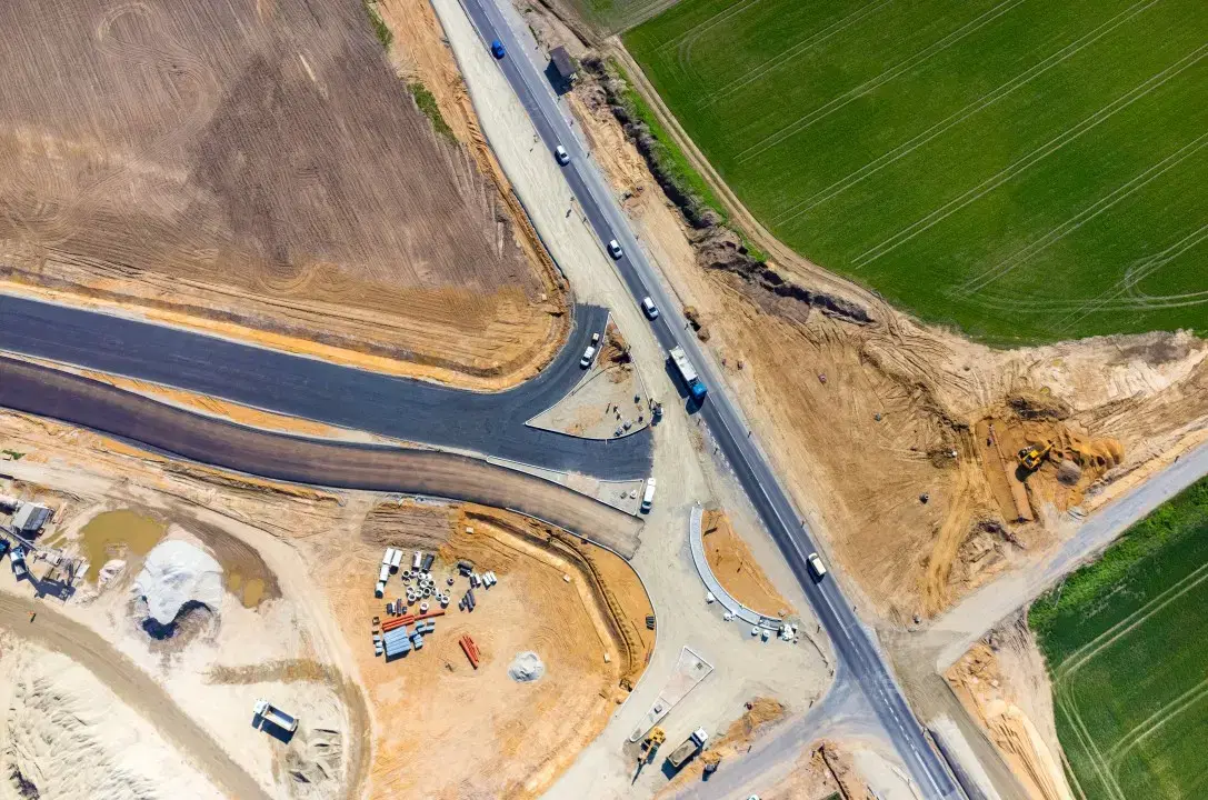
Best for open terrain, construction site mapping, agricultural drone mapping, solar farms, and land surveys where visual surface data is sufficient using drones for surveying and mapping.
- 2-5cm GSD orthomosaics
- DSM, DTM, contour maps
- Fastest turnaround: same day to 48 hours
- Lowest cost per acre
- Ideal for: RERA, NHAI earthwork, PMFBY, solar EPC using drone survey services
LiDAR Survey
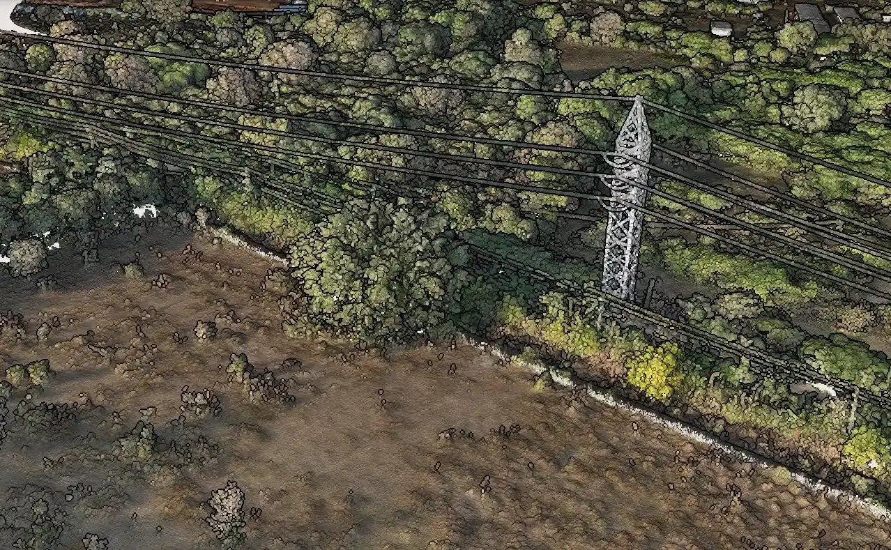
Advanced TechnologyBest for vegetated terrain, forested mining corridors, utility and powerline routes, and any project where bare-earth accuracy under canopy is required.
- ±2-5cm point cloud accuracy
- Bare-earth DTM through vegetation
- Classified LAS/LAZ point clouds
- Penetrates vegetation and dust
- Ideal for: IBM Rule 34A in forested mines, NHAI corridor DPRs, powerline vegetation encroachment, railway alignment surveys
Both Technologies Deliver:
DXF / DWG for AutoCAD · GeoTIFF for raster outputs · LAS/LAZ for point clouds · KML/KMZ · PDF compliance reports · ArcGIS, QGIS, Civil 3D, Bentley MicroStation compatible
Why Survey Projects Stall in India - and How We Eliminate Each Problem
Four problems that cost you time and money - and exactly how we eliminate each one.
Vendor delays cost you money
Site sits idle. Contractor mobilisation is wasted. Deadlines slip. You pay for someone else's scheduling problem.
DGCA-certified teams with both photogrammetry and LiDAR equipment deployed within agreed timelines across all major project belts - Odisha to Gujarat, Rajasthan to Karnataka. One vendor. One call.
Wrong report format means rejected submissions
IBM Rule 34A, RERA, NHAI, DGMS, SECI - each authority has precise format requirements. One wrong field and your submission comes back. Weeks lost.
Every deliverable is pre-formatted for its specific regulatory authority before leaving our processing team. We know what IBM wants, what NHAI accepts, and what RERA requires. No rework.
You can't verify contractor earthwork claims
Contractor bills for 50,000 cubic metres. You have no independent record. Disputes, cost overruns, and legal exposure follow.
Survey-grade drone and LiDAR measurements give you a defensible, time-stamped volume record tied to real GPS coordinates. Court-admissible. Accepted by project lenders and independent engineers.
Standard photogrammetry fails in vegetated or dusty terrain
Your mining lease is forested. Your highway corridor runs through dense scrub. Standard drone cameras can't see through canopy to bare earth - your survey comes back wrong.
LiDAR penetrates vegetation and dust to deliver accurate bare-earth terrain regardless of surface conditions. We recommend LiDAR where photogrammetry will fail - and quote both options so you choose.
How It Works
Four steps from your first message to survey data in your hands.
Share Your Site Details
Tell us the location, area, project type, terrain conditions, and timeline. You receive a written quote within 2 hours - photogrammetry, LiDAR, or both - with no site visit required.
We Handle All Planning
Flight path design, GCP layout, LiDAR sensor configuration, DGCA airspace clearance, and equipment allocation are handled end-to-end. Nothing falls on your team.
Certified Pilots Survey Your Site
DGCA-certified pilots deploy with RTK drones and LiDAR sensors as required. Complete site coverage in one mobilisation. Done right.
Deliverables Arrive in 24-48 Hours
Orthomosaics, DSMs, DTMs, LiDAR point clouds, contour maps, volumetric reports, and compliance outputs - delivered in the formats your project needs, ready to use.
Drone Mapping Services for Every Project Type
Drone surveying and mapping solutions with photogrammetry software and LiDAR survey for every project type across India.
Topographic Drone Survey
Survey-grade terrain mapping with GCP/RTK for civil engineering, infrastructure, and land development projects across India.
Mining and Quarry Survey
IBM Rule 34A compliant surveys for stockpile volume measurement, pit progression tracking, and DGMS compliance. LiDAR available for forested and vegetated lease areas.
Construction Site Monitoring
Monthly progress monitoring, RERA documentation, earthwork verification, and as-built records for NHAI, CPWD, and private developers.

Land and Property Survey
Boundary mapping, accurate area calculations, and geo-referenced orthomosaics for developers, landowners, and legal documentation.
Road and Highway Survey
Corridor mapping, cross-sections, and earthwork calculations for NHAI, MoRTH, expressway, flyover, and state highway projects. LiDAR for vegetated or complex terrain corridors.

Industrial and Solar Site Survey
Factory, warehouse, industrial park, and solar EPC surveys for SECI, NTPC, and PM-KUSUM projects. Terrain models, thermal inspection, and design-ready outputs.

Agriculture Drone Survey
NDVI crop health mapping, stand counts, PMFBY damage reports, and variable-rate prescription maps for Indian farms and agribusinesses.

Utility and Powerline Survey
Transmission line, substation, and telecom tower surveys with LiDAR-based vegetation encroachment mapping and clearance analysis.

Oil and Gas Pipeline Survey
Pipeline ROW monitoring, thermal inspection, storage asset checks, and OISD or PNGRB-ready documentation for oil and gas assets.
LiDAR Survey Services
Dedicated LiDAR surveys for projects requiring bare-earth terrain under vegetation, high-density point clouds, or survey-grade accuracy in challenging terrain conditions.

Hydrological Survey Services
Terrain data and hydrological analysis for flood modelling, drainage design, bridge hydraulics, and water infrastructure. HEC-HMS/HEC-RAS ready datasets for NHAI, CWC, CPWD, and state authorities.
Railway and Metro Survey
Drone photogrammetry and LiDAR for Indian Railways new line, doubling, gauge conversion, and metro corridor projects. RITES-specification topographic maps, DPR terrain data, construction progress monitoring, and waterway adequacy reports for RVNL, DFCC, IRCON, and metro authorities.
What You Get When You Work With Aeroyantra
Four key advantages that change every part of your survey experience.
Data in 24–48 Hours
In-house processing infrastructure - no third-party software queues. Your project schedule does not wait for our software vendor. LiDAR data processed and classified in-house, same turnaround.
Lower Cost Per Acre
No external software licensing overhead passed to you. Owned infrastructure means better pricing for every project size - whether it's a 5-acre RERA plot or a 500km NHAI corridor.
Compliance-Ready First Time
IBM Rule 34A, NHAI, RERA, DGMS, SECI - deliverables pre-structured for the authority that needs them. LiDAR point clouds classified and formatted to project specification before delivery.
One Vendor for Photogrammetry and LiDAR
No need to coordinate two separate survey vendors for different site conditions. We assess your terrain, recommend the right technology, and deliver from one team under one contract.
What a Successful Survey Engagement Looks Like
When survey data arrives on time and in the right format, your entire project runs differently.
Where We Have Worked
Aeroyantra has surveyed 110+ sites across India - mining companies in Odisha and Jharkhand (IBM Rule 34A, DGMS compliance), solar EPC contractors in Rajasthan and Gujarat (SECI, PM-KUSUM documentation), NHAI corridor projects in Maharashtra and Karnataka (cross-sections, earthwork verification), real estate developers in Bengaluru, Hyderabad, and Pune (RERA submissions), agricultural projects across Punjab, Haryana, and Madhya Pradesh (PMFBY, NDVI), and utility and powerline corridors in Andhra Pradesh and Telangana (LiDAR vegetation mapping).
Recognition
Recognized by Startup India (DPIIT), supporting innovation in drone data processing and survey intelligence.

Pan-India Survey Deployment
We deploy DGCA-certified photogrammetry and LiDAR survey teams to all major project belts across India.
Metro Cities
Delhi NCR · Mumbai · Bengaluru · Hyderabad · Chennai · Kolkata · Pune · Ahmedabad
Project Belts
Odisha & Jharkhand (mining, LiDAR forested terrain) · Rajasthan & Gujarat (solar, open terrain photogrammetry) · Maharashtra & Karnataka (NHAI corridors, LiDAR DPR surveys)
Punjab, Haryana & MP (agriculture, multispectral) · Andhra Pradesh & Telangana (infrastructure, utility LiDAR) · Uttarakhand & Himachal (hilly terrain, LiDAR preferred)
Don't see your location? We cover all states. WhatsApp us your site location for a deployment timeline.
Frequently Asked Questions
Common questions from project managers, procurement leads, and site engineers across India.
Yes. All our pilots hold valid DGCA Remote Pilot Licences (RPL) and operate under Drone Rules 2021 with Digital Sky platform coordination. We handle airspace clearance, NOC requirements, and all pre-flight compliance - nothing falls on your team. Our drones are registered and insured, so your site remains fully compliant throughout.