LiDAR Drone Surveys for Terrain, Corridors, and Difficult Ground - Delivered in 48 Hours
Standard drone photogrammetry cannot see through vegetation, dust, or dense canopy. When your mine lease is forested, your highway corridor runs through scrub, or your powerline ROW has heavy tree growth, LiDAR is the right tool. Our DGCA-certified teams deploy with multi-return LiDAR sensors, capture accurate bare-earth terrain regardless of surface conditions, and deliver classified point clouds, DTMs, and engineering-ready outputs within 48 hours.
LiDAR Survey Package
Structured for projects where standard photogrammetry is insufficient or unreliable.
DGCA-Compliant Flight Operations
LiDAR sensor flights planned and executed under Drone Rules 2021 with Digital Sky coordination and site-specific airspace management.
Multi-Return Point Cloud Capture
Multi-return LiDAR sensors capture ground, vegetation, structure, and canopy returns in a single pass - delivering complete scene geometry.
In-House Point Cloud Processing
All classification, filtering, and DTM/DSM generation is handled in-house. No third-party processing queues. Your data does not leave our pipeline.
Engineering-Ready Deliverables
Outputs are formatted for AutoCAD, Civil 3D, ArcGIS, QGIS, Bentley MicroStation, and standard GIS workflows before delivery.
What You Receive
When LiDAR Is the Right Choice for Your Project
Standard drone photogrammetry works well on open terrain. LiDAR is the right technology when your site has conditions that prevent reliable bare-earth capture from imagery alone.
| Situation | Why LiDAR Wins |
|---|---|
| Forested or vegetated terrain | Multi-return pulses penetrate canopy to reach bare ground |
| Mining leases with scrub cover | Accurate pit, bench, and dump terrain under vegetation |
| NHAI corridors through dense scrub | Bare-earth profiles for earthwork and drainage design |
| Powerline ROW with tree growth | Conductor-to-vegetation clearance with precise ground model |
| Dusty or haze-heavy sites | LiDAR is unaffected by airborne dust that degrades imagery |
| Engineering-grade DTM requirement | Higher confidence terrain model than photogrammetry alone |
| Railway alignment surveys | Precise ground model through vegetation for design inputs |
LiDAR Survey Applications - Aerial Survey and Drone Mapping Services
Specialised LiDAR survey workflows for terrain, corridors, compliance, and engineering using advanced aerial photogrammetry and drone surveying and mapping.
Mining and Quarry Drone LiDAR Mapping
Drone LiDAR mapping for forested or vegetated mine leases where standard photogrammetry cannot reliably capture bare-earth terrain. The preferred aerial survey method for IBM-compliant mining submissions.
Road and Highway Corridors
LiDAR corridor mapping for NHAI, MoRTH, expressway, and state highway projects through vegetated or difficult terrain.
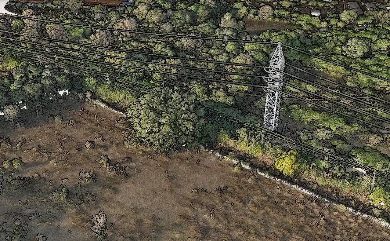
Transmission Line and Utility ROW
Multi-return LiDAR for conductor modeling, vegetation encroachment detection, and clearance analysis across transmission corridors.
Railway Corridor and Alignment
LiDAR terrain capture for railway alignment studies, embankment surveys, drainage design, and vegetation encroachment along rail corridors.
Oil and Gas Pipeline ROW
LiDAR for pipeline right-of-way monitoring, surface change detection, and terrain mapping across difficult terrain.
Topographical Survey and Civil Engineering with LiDAR
High-confidence LiDAR topographical survey and aerial mapping for flood modelling, drainage design, GIS mapping, urban planning, and civil engineering where photogrammetry alone is insufficient.
India Regulatory and Authority Support
LiDAR outputs structured for Indian project authorities, engineering teams, and regulatory bodies.
IBM Rule 34A Mining Support
LiDAR terrain data formatted to support IBM annual returns and quarterly compliance packages for mine lease areas with vegetation or difficult ground conditions.
NHAI and MoRTH Documentation
Corridor terrain outputs structured for NHAI DPR submissions, independent engineer reviews, and EPC billing verification.
Power Grid and State Transco Corridors
LiDAR deliverables formatted for Power Grid Corporation, state transco, and private transmission operator asset management and maintenance workflows.
CPCB and Environmental Compliance
Terrain and vegetation data for environmental monitoring, landfill airspace, and post-closure surveys.
State and Urban Development Authorities
Drone LiDAR mapping terrain for Smart City Mission, AMRUT, and urban development authority GIS mapping and aerial mapping base layers.
What a LiDAR Survey Engagement Looks Like
Site Assessment and Technology Recommendation
We review your site conditions, terrain type, and project requirements. We confirm whether LiDAR, photogrammetry, or a combined approach is the right fit - and quote accordingly.
Flight Planning and Compliance
LiDAR sensor configuration, flight altitude, overlap parameters, DGCA airspace clearance, and Digital Sky coordination are handled in full before mobilisation.
On-Site LiDAR Capture
DGCA-certified pilots deploy with multi-return LiDAR sensors. Complete site or corridor coverage in one mobilisation.
Point Cloud Processing and Classification
Raw point cloud data is processed, filtered, and classified in-house. Ground, vegetation, structure, and noise classes are separated to your project specification.
Deliverables and Engineering Support
You receive classified point clouds, DTMs, contour maps, cross-sections, and all required outputs in your specified formats - with walkthrough support if needed.
Combined LiDAR + Photogrammetry Package
For many projects we recommend a combined approach - LiDAR for bare-earth terrain in vegetated areas, photogrammetry for high-resolution visual documentation of open areas.
Frequently Asked Questions
Common questions about LiDAR drone surveys in India
Use LiDAR when your site has vegetation, tree cover, scrub, or dust that prevents a camera from reliably capturing bare-earth elevation. LiDAR fires laser pulses that penetrate canopy and return accurate ground data regardless of surface conditions. For open terrain such as construction sites, solar farms, and agricultural land, photogrammetry is faster and more cost-effective. We assess your site as part of the quoting process and recommend the right technology.
LiDAR Survey Quote - Response in 2 Hours
Share your site location, terrain type, corridor length, and project requirement. We assess whether LiDAR is the right fit and send a written quote within 2 hours. DGCA-certified pilots deployed across all major project belts in India.