Drone Aerial Photography and Video Services in India
Drone aerial photography and videography for construction progress, highway projects, real estate and industrial sites in India, flown by DGCA-certified pilots.
Drone Aerial Photography and Video Services in India
Drone aerial photography and videography for construction progress, highway projects, real estate and industrial sites in India, flown by DGCA-certified pilots.

By Vishal Singh Dhami, Co-Founder & Director
6 min read · Updated
Recurring construction progress visits in India typically cost ₹25,000-₹60,000 per visit at market rates. One-off shoots are quoted on location and deliverables, in writing within 2 hours.
Aerial Photography and Video That Does a Job
Most project teams do not need a showreel. They need a clear aerial record of the site this month, a video the board or the lender can follow, photos that show what changed since the last visit, and visuals good enough for the brochure. Aeroyantra provides drone aerial photography services and videography for exactly that, with the same DGCA-certified pilots who fly its surveys.
Because the shoot is run by a survey company, the footage is not just pictures. Videos can be synced to the drone's flight path on the site map, photos can be measured, and the same visit can include a mapping flight that produces an orthomosaic and 3D model.
What Aeroyantra Shoots
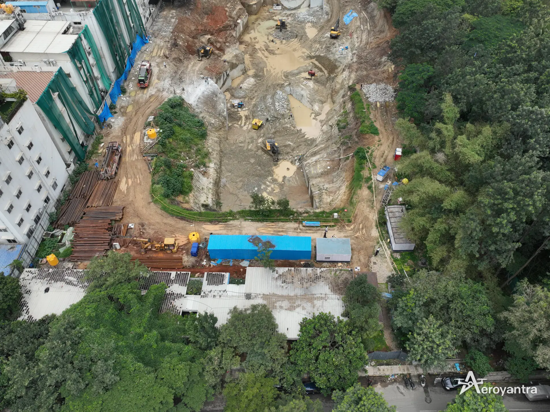
- Aerial stills - high-resolution, geotagged photographs from oblique and overhead viewpoints.
- Progress video - fly-overs and orbits of the site and structures, repeated from the same viewpoints each visit so months can be compared.
- Corridor runs - continuous video along roads, pipelines and transmission lines.
- Asset and inspection footage - close passes of structures, roofs, towers and plant for condition review.
- Marketing visuals - finished projects, aerial context and location shots for sales material.
- Optional mapping flight - an orthomosaic, DSM/DTM and 3D model from the same visit. See aerial survey services.
Who Uses Drone Aerial Photography
| Client | What they use it for |
|---|---|
| Real estate developers | Monthly progress updates for buyers and investors, sales visuals |
| Construction and EPC contractors | Progress records, client reporting, claims evidence |
| Highway projects | Monthly drone video on NHAI projects, corridor progress |
| Industrial plants and solar parks | Plant documentation, inspections, stakeholder presentations |
| Lenders and owners' engineers | Independent visual progress before releasing payments |
For highway work, the requirement is formal: NHAI requires monthly drone video recordings on highway projects. Aeroyantra runs those shoots alongside road and highway surveys so the video and the measured progress come from one visit.
Video Synced to the Flight Path
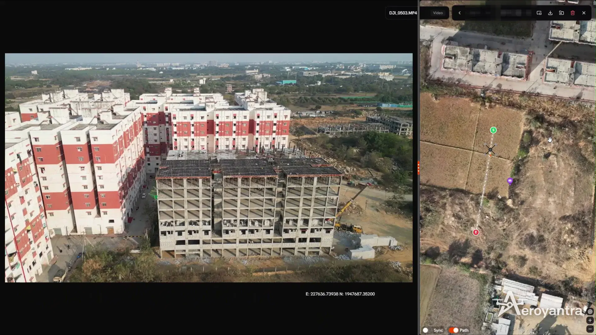
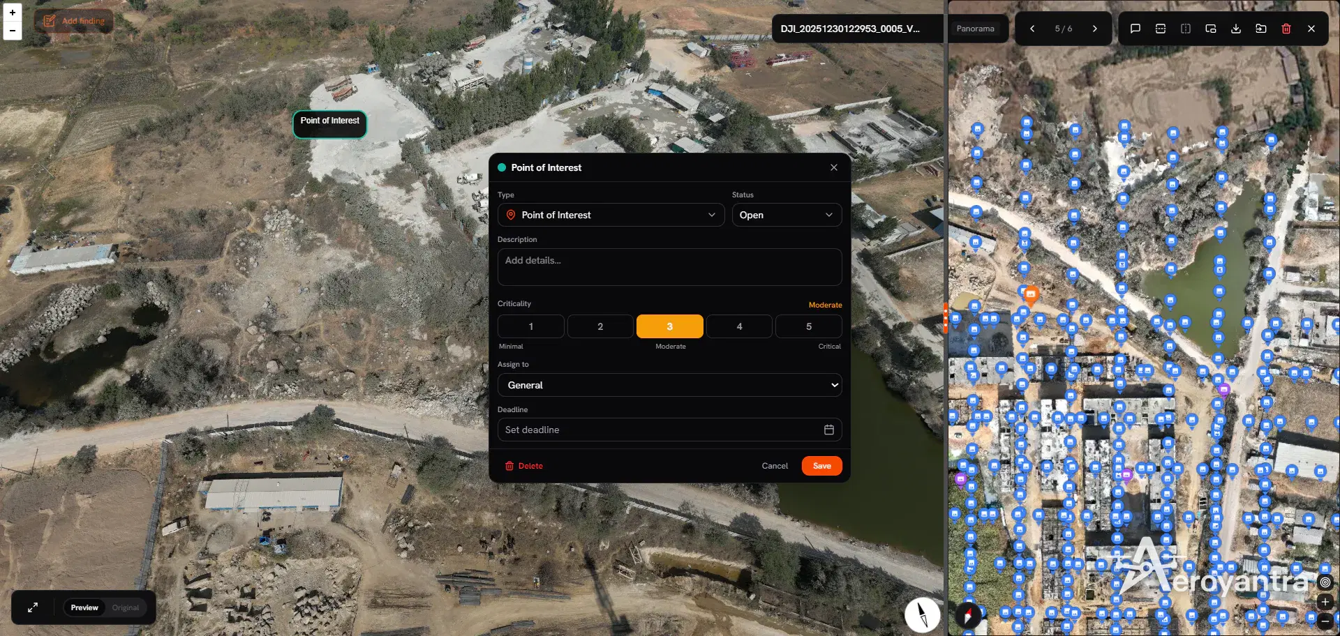
Aeroyantra loads drone video into the project platform with its DJI flight log, so the drone's path is drawn on the site map and its position moves along the path as the video plays. Viewers always know where they are looking from - which turns a fly-over into a site record rather than a clip.
Photos You Can Measure
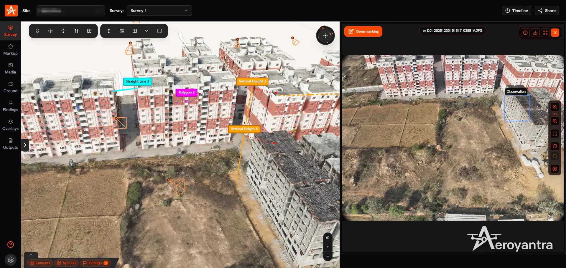
Aerial photos in the platform sit next to the site's 3D model. Mark them up, measure on them, and log findings with a severity from Low to Critical, an assignee and a deadline - useful when the shoot doubles as a condition inspection.
Progress, Month by Month
Shot from the same viewpoints on every visit, aerial photography becomes a progress timeline. Add a mapping flight and the comparison becomes measurable: split-screen orthomosaics between dates, and volumes moved between surveys. For walking-level detail inside buildings, pair the aerial record with 360 site walkthroughs.
For continuous site security and encroachment monitoring rather than progress, see drone surveillance.
Compliance
Every Aeroyantra shoot is flown by a DGCA-certified remote pilot on a registered drone under the Drone Rules 2021. Before mobilising, the team checks the Digital Sky airspace zone: Green Zone shoots need no further permission, while Yellow and Red Zones, airports, defence areas and borders need permission through Digital Sky, which Aeroyantra arranges. Our drone survey cost guide covers the regulatory changes in more detail.
How a Shoot Works
- Brief. Site location, what the footage is for, the shot list, and how often (one-off or monthly).
- Quote. A written quote within 2 hours.
- Airspace and planning. Zone check, any permission, flight plan and viewpoints.
- Shoot. DGCA-certified pilots fly the shot list, plus a mapping flight if ordered.
- Delivery. Edited video, raw footage and stills, and the footage loaded to your project site with its flight path when it is part of a survey programme.
Pricing
Recurring construction progress visits in India typically cost ₹25,000-₹60,000 per visit at market rates, depending on site size and deliverables; repeat programmes usually earn volume discounts. One-off shoots depend on location, airspace and editing. The drone survey cost guide breaks down Indian market rates, and construction monitoring covers measured progress surveys.
Frequently Asked Questions
How much does drone aerial photography cost in India?
Recurring construction progress visits in India typically cost ₹25,000-₹60,000 per visit at market rates, depending on site size and deliverables. One-off aerial photography and video shoots depend on location, airspace, the number of shots and editing. Aeroyantra sends a written quote within 2 hours of receiving the site and the brief.
Do I need permission for drone photography in India?
Commercial drone photography in India needs a registered drone with a UIN and a DGCA-certified remote pilot. In Green Zone airspace no further permission is needed; Yellow and Red Zones, airports, defence areas and borders need permission through the Digital Sky platform. Aeroyantra checks the airspace zone and arranges any permission before the shoot.
What do I get from a drone video shoot?
Aeroyantra delivers edited video and the raw footage, high-resolution aerial stills, and - when the shoot is on a site Aeroyantra maps - the video synced to its flight path in the Aeroyantra platform, so viewers see where the drone was for every frame.
Can drone video be used for construction progress reports?
Yes. Repeat aerial video and photos from the same viewpoints each month make progress visible to owners, lenders and site teams, and highway authorities increasingly expect it: NHAI requires monthly drone video recordings on highway projects. Aeroyantra can add a mapping flight on the same visit for measurable progress and volumes.
Can the same drone flight produce a map as well as photos?
Yes. A mapping flight with the right overlap produces an orthomosaic, elevation models and a 3D model in addition to photos, so Aeroyantra can combine a progress video shoot with a short survey flight on the same visit.
Keep exploring
Related services, platform features and guides
- Survey serviceConstruction SurveyProgress tracking & earthwork verificationRead more
- Survey serviceDrone SurveillanceRecurring site, boundary and corridor monitoringRead more
- GuideAerial Survey Services in India | Drone Aerial MappingAerial survey and mapping across India by DGCA-certified drone teams: photogrammetry deliverables in 24-48 hours and LiDAR in 48-72 hours.Read more
- IndustryDrone Survey for Roads | Corridor Mapping & Cut/FillAerial survey for road and highway projects. Corridor mapping, LiDAR, cut/fill analysis, and alignment verification for NHAI and state highway works.Read more
- Platform360 Site WalkthroughsWalk the site with a 360 camera; compare dates; log findingsRead more
- ArticleDrone Survey Cost in India 2026 | Per Acre PricingDrone survey cost in India for 2026. Per acre pricing breakdown by project type, deliverables, area size, and accuracy level. Compare service providers.Read more